Toledo geodata
Toledo (Ohio) is a seat of a second-order administrative division; located in United States in America/New_York (GMT-4) time zone. With population of 279,789 people, there are 79 cities with bigger population in this country. Compared to other cities in United States, 72.5% of cities are located further ↓South; 60.5% of cities are located further ←West and 52.5% of cities have higher elevation than Toledo. Note1


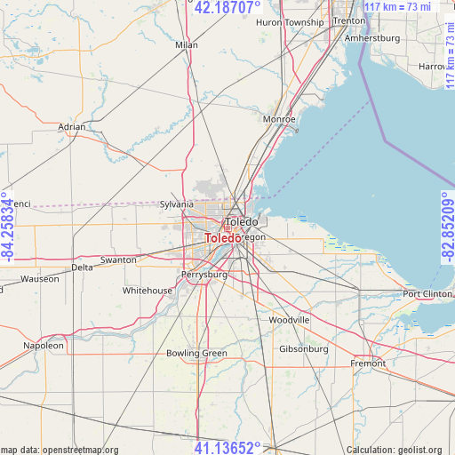
Toledo GPS coordinates[2]
41° 39' 50.184" North, 83° 33' 18.756" West
| Map corner | latitude | longitude |
|---|---|---|
| Upper-left | 42.18707°, | -84.25834° |
| Center: | 41.66394°, | -83.55521° |
| Lower-right: | 41.13652°, | -82.85209° |
| Map W x H: | 116.8×116.8 km | = 72.6×72.6mi |
| max Lat: | 71.29058° ⇑27.5% North |
| Toledo: | 41.66394° |
| min Lat: | ⇓72.5% South 19.06759° |
| min Long | Toledo | max Long |
| -171.73463° | -83.55521° | -66.98998° |
| W 60.5%⇐ | ⇒39.5% E |
Elevation
Elevation of Toledo is 189 m = 620 ft, and this is 105.8 m = 347 ft below average elevation for this country.
| Max E: |
3189 m = 10463 ft | 52.5% |
| Avg. | 294.8 m = 967 ft | |
| Toledo | 189 m = 620 ft | |
Min E: |
-60 m = -197 ft | 47.5% |
See also: Toledo elevation on elevation.city.
Geographical zone
Toledo is located in North temperate zone (between Tropic of Cancer and the Arctic Circle). Distance of this Northern Tropic circle is 2026.7 km =1259.3 mi to South.| Distance of | km | miles | from Toledo |
|---|---|---|---|
| North Pole | 5374.5 | 3339.6 | to North |
| Arctic Circle | 2768.6 | 1720.3 | to North |
| Tropic Cancer | 2026.7 | 1259.3 | to South |
| Equator | 4632.6 | 2878.6 | to South |


Nearby cities:
15 places around Toledo: (largest is in red/bold)
• Curtice
16.4 km =10.2 mi,  108°
108°
• Holland
13.8 km =8.6 mi,  250°
250°
• Lambertville
12.8 km =8 mi,  331°
331°
• Luna Pier
18.5 km =11.5 mi,  30°
30°
• Maumee
13.9 km =8.6 mi,  216°
216°
• Millbury
15.4 km =9.6 mi,  135°
135°
• Northwood
9.6 km =6 mi,  131°
131°
• Oregon
6.1 km =3.8 mi, 111°
• Ottawa Hills
7.3 km =4.5 mi,  270°
270°
• Perrysburg
13.3 km =8.3 mi,  206°
206°
• Rossford
6.1 km =3.8 mi,  187°
187°
• Sylvania
14.5 km =9 mi,  295°
295°
• Temperance
12.9 km =8 mi,  354°
354°
• Walbridge
9.9 km =6.2 mi,  148°
148°
• Waterville
22.6 km =14 mi, 216°
Sources, notices
• [Note1] Compared only with cities in United States existing in our database
• [Src1] Map data: © OpenStreetMap contributors (CC-BY-SA)
• [Src2] Other city data from geonames.org with taken over terms of usage.
• [Src3] Geographical zone / Annual Mean Temperature by Robert A. Rohde @ Wikipedia
