Potterville geodata
Potterville (Michigan) is a populated place; located in United States in America/Detroit (GMT-4) time zone. With population of 2,618 people, there are 10356 cities with bigger population in this country. Compared to other cities in United States, 80.8% of cities are located further ↓South; 56.5% of cities are located further ←West and 67.6% of cities have lower elevation than Potterville. Note1


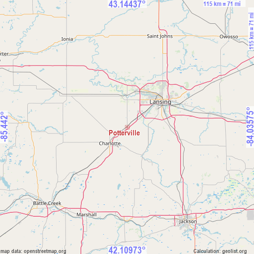
Potterville GPS coordinates[2]
42° 37' 45.12" North, 84° 44' 19.932" West
| Map corner | latitude | longitude |
|---|---|---|
| Upper-left | 43.14437°, | -85.442° |
| Center: | 42.6292°, | -84.73887° |
| Lower-right: | 42.10973°, | -84.03575° |
| Map W x H: | 115×115 km | = 71.5×71.5mi |
| max Lat: | 71.29058° ⇑19.2% North |
| Potterville: | 42.6292° |
| min Lat: | ⇓80.8% South 19.06759° |
| min Long | Potterville | max Long |
| -171.73463° | -84.73887° | -66.98998° |
| W 56.5%⇐ | ⇒43.5% E |
Elevation
Elevation of Potterville is 274 m = 899 ft, and this is 20.8 m = 68 ft below average elevation for this country.
| Max E: |
3189 m = 10463 ft | 32.4% |
| Avg. | 294.8 m = 967 ft | |
| Potterville | 274 m = 899 ft | |
Min E: |
-60 m = -197 ft | 67.6% |
See also: United States elevation on elevation.city.
Geographical zone
Potterville is located in North temperate zone (between Tropic of Cancer and the Arctic Circle). Distance of this Northern Tropic circle is 2134 km =1326 mi to South.| Distance of | km | miles | from Potterville |
|---|---|---|---|
| North Pole | 5267.1 | 3272.8 | to North |
| Arctic Circle | 2661.3 | 1653.7 | to North |
| Tropic Cancer | 2134 | 1326 | to South |
| Equator | 4739.9 | 2945.2 | to South |


Nearby cities:
15 places around Potterville: (largest is in red/bold)
• Charlotte
10.8 km =6.7 mi,  227°
227°
• Dimondale
7.6 km =4.7 mi,  76°
76°
• East Lansing
24 km =14.9 mi,  60°
60°
• Eaton Rapids
15 km =9.3 mi,  152°
152°
• Edgemont Park
17.7 km =11 mi,  42°
42°
• Grand Ledge
13.8 km =8.6 mi,  357°
357°
• Holt
18.3 km =11.4 mi,  86°
86°
• Lansing
18.9 km =11.7 mi,  52°
52°
• Mason
24.8 km =15.4 mi,  102°
102°
• Mulliken
19.6 km =12.2 mi,  318°
318°
• Olivet
25.8 km =16 mi,  216°
216°
• Sunfield
25.5 km =15.8 mi,  305°
305°
• Vermontville
23.3 km =14.5 mi,  269°
269°
• Wacousta
22.3 km =13.9 mi,  8°
8°
• Waverly
15.6 km =9.7 mi, 38°
Sources, notices
• [Note1] Compared only with cities in United States existing in our database
• [Src1] Map data: © OpenStreetMap contributors (CC-BY-SA)
• [Src2] Other city data from geonames.org with taken over terms of usage.
• [Src3] Geographical zone / Annual Mean Temperature by Robert A. Rohde @ Wikipedia
