Quinnesec geodata
Quinnesec (Michigan) is a populated place; located in United States in America/Menominee (GMT-5) time zone. With population of 1,191 people, there are 15173 cities with bigger population in this country. Compared to other cities in United States, 94.8% of cities are located further ↓South; 52.8% of cities are located further →East and 75.4% of cities have lower elevation than Quinnesec. Note1
Administrative division(s):
- Level 1: Michigan
- Level 2: Dickinson County
- Level 3: Charter Township of Breitung


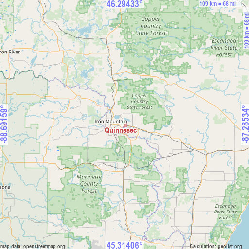
Quinnesec GPS coordinates[2]
45° 48' 22.86" North, 87° 59' 18.456" West
| Map corner | latitude | longitude |
|---|---|---|
| Upper-left | 46.29433°, | -88.69159° |
| Center: | 45.80635°, | -87.98846° |
| Lower-right: | 45.31406°, | -87.28534° |
| Map W x H: | 109×109 km | = 67.7×67.7mi |
| max Lat: | 71.29058° ⇑5.2% North |
| Quinnesec: | 45.80635° |
| min Lat: | ⇓94.8% South 19.06759° |
| min Long | Quinnesec | max Long |
| -171.73463° | -87.98846° | -66.98998° |
| W 47.2%⇐ | ⇒52.8% E |
Elevation
Elevation of Quinnesec is 316 m = 1037 ft, and this is 21.2 m = 70 ft above average elevation for this country.
| Max E: |
3189 m = 10463 ft | 24.6% |
| Quinnesec | 316 m 1037 ft | |
| Avg. | 294.8 m = 967 ft | |
Min E: |
-60 m = -197 ft | 75.4% |
See also: United States elevation on elevation.city.
Geographical zone
Quinnesec is located in North temperate zone (between Tropic of Cancer and the Arctic Circle). Distance of this North polar circle is 2308 km =1434.1 mi to North.| Distance of | km | miles | from Quinnesec |
|---|---|---|---|
| North Pole | 4913.9 | 3053.4 | to North |
| Arctic Circle | 2308 | 1434.1 | to North |
| Tropic Cancer | 2487.3 | 1545.5 | to South |
| Equator | 5093.2 | 3164.8 | to South |


Nearby cities:
15 places around Quinnesec: (largest is in red/bold)
• Caspian
57.5 km =35.7 mi,  299°
299°
• Crivitz
63.8 km =39.6 mi,  181°
181°
• Crystal Falls
42 km =26.1 mi,  320°
320°
• Florence
24.1 km =15 mi, 302°
• Iron Mountain
6.2 km =3.9 mi,  284°
284°
• Iron River
59.7 km =37.1 mi, 302°
• Kingsford
6.6 km =4.1 mi,  258°
258°
• Laona
59.6 km =37 mi,  243°
243°
• Middle Inlet
57.2 km =35.5 mi, 180°
• Niagara
3.9 km =2.4 mi,  187°
187°
• Norway
6.9 km =4.3 mi,  108°
108°
• Stambaugh, Iron River
58.1 km =36.1 mi, 301°
• Stephenson
52.6 km =32.7 mi,  145°
145°
• Wabeno
66.4 km =41.3 mi,  231°
231°
• Wausaukee
48.5 km =30.1 mi, 176°
Sources, notices
• [Note1] Compared only with cities in United States existing in our database
• [Src1] Map data: © OpenStreetMap contributors (CC-BY-SA)
• [Src2] Other city data from geonames.org with taken over terms of usage.
• [Src3] Geographical zone / Annual Mean Temperature by Robert A. Rohde @ Wikipedia
