Stephenson geodata
Stephenson (Michigan) is a populated place; located in United States in America/Menominee (GMT-5) time zone. With population of 867 people, there are 17219 cities with bigger population in this country. Compared to other cities in United States, 93.8% of cities are located further ↓South; 51% of cities are located further →East and 51.9% of cities have lower elevation than Stephenson. Note1


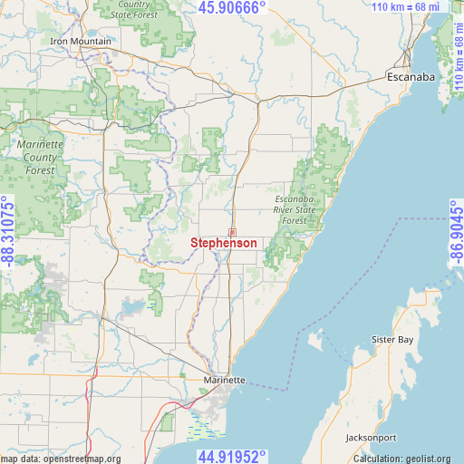
Stephenson GPS coordinates[2]
45° 24' 54.9" North, 87° 36' 27.432" West
| Map corner | latitude | longitude |
|---|---|---|
| Upper-left | 45.90666°, | -88.31075° |
| Center: | 45.41525°, | -87.60762° |
| Lower-right: | 44.91952°, | -86.9045° |
| Map W x H: | 109.8×109.8 km | = 68.2×68.2mi |
| max Lat: | 71.29058° ⇑6.2% North |
| Stephenson: | 45.41525° |
| min Lat: | ⇓93.8% South 19.06759° |
| min Long | Stephenson | max Long |
| -171.73463° | -87.60762° | -66.98998° |
| W 49%⇐ | ⇒51% E |
Elevation
Elevation of Stephenson is 206 m = 676 ft, and this is 88.8 m = 291 ft below average elevation for this country.
| Max E: |
3189 m = 10463 ft | 48.1% |
| Avg. | 294.8 m = 967 ft | |
| Stephenson | 206 m = 676 ft | |
Min E: |
-60 m = -197 ft | 51.9% |
See also: United States elevation on elevation.city.
Geographical zone
Stephenson is located in North temperate zone (between Tropic of Cancer and the Arctic Circle). Distance of this North polar circle is 2351.5 km =1461.2 mi to North.| Distance of | km | miles | from Stephenson |
|---|---|---|---|
| North Pole | 4957.4 | 3080.4 | to North |
| Arctic Circle | 2351.5 | 1461.2 | to North |
| Tropic Cancer | 2443.8 | 1518.5 | to South |
| Equator | 5049.7 | 3137.7 | to South |


Nearby cities:
15 places around Stephenson: (largest is in red/bold)
• Coleman
51.3 km =31.9 mi,  220°
220°
• Crivitz
37.3 km =23.2 mi,  236°
236°
• Escanaba
56 km =34.8 mi,  49°
49°
• Iron Mountain
57.4 km =35.7 mi,  321°
321°
• Kingsford
55.6 km =34.5 mi, 319°
• Marinette
35.1 km =21.8 mi,  182°
182°
• Menominee
34.2 km =21.3 mi, 180°
• Middle Inlet
33.1 km =20.6 mi,  245°
245°
• Niagara
49.8 km =30.9 mi, 322°
• Norway
47.3 km =29.4 mi,  330°
330°
• Peshtigo
41.6 km =25.8 mi,  195°
195°
• Quinnesec
52.6 km =32.7 mi, 325°
• Sister Bay
45.7 km =28.4 mi,  123°
123°
• Washington
52.8 km =32.8 mi,  92°
92°
• Wausaukee
27.4 km =17 mi,  259°
259°
Sources, notices
• [Note1] Compared only with cities in United States existing in our database
• [Src1] Map data: © OpenStreetMap contributors (CC-BY-SA)
• [Src2] Other city data from geonames.org with taken over terms of usage.
• [Src3] Geographical zone / Annual Mean Temperature by Robert A. Rohde @ Wikipedia
