Southfield geodata
Southfield (Michigan) is a populated place; located in United States in America/Detroit (GMT-4) time zone. With population of 73,156 people, there are 563 cities with bigger population in this country. Compared to other cities in United States, 79.6% of cities are located further ↓South; 61.4% of cities are located further ←West and 53.5% of cities have lower elevation than Southfield. Note1


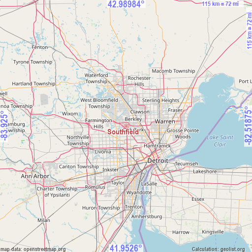
Southfield GPS coordinates[2]
42° 28' 24.132" North, 83° 13' 18.732" West
| Map corner | latitude | longitude |
|---|---|---|
| Upper-left | 42.98984°, | -83.925° |
| Center: | 42.47337°, | -83.22187° |
| Lower-right: | 41.9526°, | -82.51875° |
| Map W x H: | 115.3×115.3 km | = 71.6×71.6mi |
| max Lat: | 71.29058° ⇑20.4% North |
| Southfield: | 42.47337° |
| min Lat: | ⇓79.6% South 19.06759° |
| min Long | Southfield | max Long |
| -171.73463° | -83.22187° | -66.98998° |
| W 61.4%⇐ | ⇒38.6% E |
Elevation
Elevation of Southfield is 212 m = 696 ft, and this is 82.8 m = 272 ft below average elevation for this country.
| Max E: |
3189 m = 10463 ft | 46.5% |
| Avg. | 294.8 m = 967 ft | |
| Southfield | 212 m = 696 ft | |
Min E: |
-60 m = -197 ft | 53.5% |
See also: Southfield elevation on elevation.city.
Geographical zone
Southfield is located in North temperate zone (between Tropic of Cancer and the Arctic Circle). Distance of this Northern Tropic circle is 2116.7 km =1315.3 mi to South.| Distance of | km | miles | from Southfield |
|---|---|---|---|
| North Pole | 5284.5 | 3283.6 | to North |
| Arctic Circle | 2678.6 | 1664.4 | to North |
| Tropic Cancer | 2116.7 | 1315.3 | to South |
| Equator | 4722.6 | 2934.5 | to South |


Nearby cities:
15 places around Southfield: (largest is in red/bold)
• Berkley
4.6 km =2.9 mi,  43°
43°
• Beverly Hills
5.6 km =3.5 mi,  358°
358°
• Bingham Farms
6.3 km =3.9 mi,  318°
318°
• Birmingham
8.2 km =5.1 mi,  6°
6°
• Clawson
9.1 km =5.7 mi, 42°
• Ferndale
7.3 km =4.5 mi,  101°
101°
• Franklin
8.8 km =5.5 mi,  308°
308°
• Hazel Park
9.7 km =6 mi, 97°
• Huntington Woods
4.6 km =2.9 mi,  79°
79°
• Lathrup Village
2.6 km =1.6 mi, 358°
• Madison Heights
9.7 km =6 mi, 81°
• Oak Park
3.6 km =2.2 mi,  115°
115°
• Pleasant Ridge
6.5 km =4 mi,  92°
92°
• Redford
11.7 km =7.3 mi,  211°
211°
• Royal Oak
6.6 km =4.1 mi,  74°
74°
Sources, notices
• [Note1] Compared only with cities in United States existing in our database
• [Src1] Map data: © OpenStreetMap contributors (CC-BY-SA)
• [Src2] Other city data from geonames.org with taken over terms of usage.
• [Src3] Geographical zone / Annual Mean Temperature by Robert A. Rohde @ Wikipedia
