Redford geodata
Redford (Michigan) is a populated place; located in United States in America/Detroit (GMT-4) time zone. With population of 49,936 people, there are 952 cities with bigger population in this country. Compared to other cities in United States, 78.8% of cities are located further ↓South; 61.2% of cities are located further ←West and 52.2% of cities have higher elevation than Redford. Note1
Administrative division(s):
- Level 1: Michigan
- Level 2: Wayne County
- Level 3: Charter Township of Redford


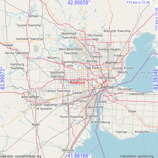
Redford GPS coordinates[2]
42° 23' 0.132" North, 83° 17' 47.76" West
| Map corner | latitude | longitude |
|---|---|---|
| Upper-left | 42.90058°, | -83.99973° |
| Center: | 42.38337°, | -83.2966° |
| Lower-right: | 41.86186°, | -82.59348° |
| Map W x H: | 115.5×115.5 km | = 71.8×71.8mi |
| max Lat: | 71.29058° ⇑21.2% North |
| Redford: | 42.38337° |
| min Lat: | ⇓78.8% South 19.06759° |
| min Long | Redford | max Long |
| -171.73463° | -83.2966° | -66.98998° |
| W 61.2%⇐ | ⇒38.8% E |
Elevation
Elevation of Redford is 190 m = 623 ft, and this is 104.8 m = 344 ft below average elevation for this country.
| Max E: |
3189 m = 10463 ft | 52.2% |
| Avg. | 294.8 m = 967 ft | |
| Redford | 190 m = 623 ft | |
Min E: |
-60 m = -197 ft | 47.8% |
See also: Redford elevation on elevation.city.
Geographical zone
Redford is located in North temperate zone (between Tropic of Cancer and the Arctic Circle). Distance of this Northern Tropic circle is 2106.7 km =1309 mi to South.| Distance of | km | miles | from Redford |
|---|---|---|---|
| North Pole | 5294.5 | 3289.8 | to North |
| Arctic Circle | 2688.6 | 1670.6 | to North |
| Tropic Cancer | 2106.7 | 1309 | to South |
| Equator | 4712.6 | 2928.3 | to South |


Nearby cities:
15 places around Redford: (largest is in red/bold)
• Bingham Farms
14.9 km =9.3 mi,  7°
7°
• Dearborn
12 km =7.5 mi,  124°
124°
• Dearborn Heights
5.5 km =3.4 mi,  159°
159°
• Farmington
11.1 km =6.9 mi,  324°
324°
• Farmington Hills
13.1 km =8.1 mi,  329°
329°
• Garden City
7 km =4.3 mi,  203°
203°
• Inkster
10 km =6.2 mi,  186°
186°
• Lathrup Village
14 km =8.7 mi,  25°
25°
• Livonia
4.9 km =3 mi,  250°
250°
• Melvindale
15 km =9.3 mi,  138°
138°
• Oak Park
12.6 km =7.8 mi,  47°
47°
• Plymouth
14.3 km =8.9 mi,  264°
264°
• Southfield
11.7 km =7.3 mi, 31°
• Wayne
13.5 km =8.4 mi,  213°
213°
• Westland
10.8 km =6.7 mi,  232°
232°
Sources, notices
• [Note1] Compared only with cities in United States existing in our database
• [Src1] Map data: © OpenStreetMap contributors (CC-BY-SA)
• [Src2] Other city data from geonames.org with taken over terms of usage.
• [Src3] Geographical zone / Annual Mean Temperature by Robert A. Rohde @ Wikipedia
