Escanaba geodata
Escanaba (Michigan) is a seat of a second-order administrative division; located in United States in America/Detroit (GMT-4) time zone. With population of 12,334 people, there are 3811 cities with bigger population in this country. Compared to other cities in United States, 94.6% of cities are located further ↓South; 50.1% of cities are located further ←West and 54.8% of cities have higher elevation than Escanaba. Note1


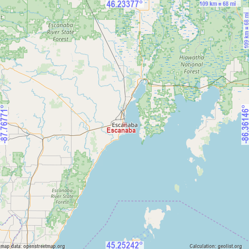
Escanaba GPS coordinates[2]
45° 44' 42.9" North, 87° 3' 52.488" West
| Map corner | latitude | longitude |
|---|---|---|
| Upper-left | 46.23377°, | -87.76771° |
| Center: | 45.74525°, | -87.06458° |
| Lower-right: | 45.25242°, | -86.36146° |
| Map W x H: | 109.1×109.1 km | = 67.8×67.8mi |
| max Lat: | 71.29058° ⇑5.4% North |
| Escanaba: | 45.74525° |
| min Lat: | ⇓94.6% South 19.06759° |
| min Long | Escanaba | max Long |
| -171.73463° | -87.06458° | -66.98998° |
| W 50.1%⇐ | ⇒49.9% E |
Elevation
Elevation of Escanaba is 181 m = 594 ft, and this is 113.8 m = 373 ft below average elevation for this country.
| Max E: |
3189 m = 10463 ft | 54.8% |
| Avg. | 294.8 m = 967 ft | |
| Escanaba | 181 m = 594 ft | |
Min E: |
-60 m = -197 ft | 45.2% |
See also: United States elevation on elevation.city.
Geographical zone
Escanaba is located in North temperate zone (between Tropic of Cancer and the Arctic Circle). Distance of this North polar circle is 2314.8 km =1438.3 mi to North.| Distance of | km | miles | from Escanaba |
|---|---|---|---|
| North Pole | 4920.7 | 3057.6 | to North |
| Arctic Circle | 2314.8 | 1438.3 | to North |
| Tropic Cancer | 2480.5 | 1541.3 | to South |
| Equator | 5086.4 | 3160.5 | to South |


Nearby cities:
15 places around Escanaba: (largest is in red/bold)
• Gladstone
12.4 km =7.7 mi,  15°
15°
• Gwinn
66.3 km =41.2 mi,  333°
333°
• Iron Mountain
78.1 km =48.5 mi,  276°
276°
• K. I. Sawyer Air Force Base
71.3 km =44.3 mi,  339°
339°
• Kingsford
78.3 km =48.7 mi,  274°
274°
• Manistique
67.6 km =42 mi,  69°
69°
• Menominee
82.9 km =51.5 mi,  211°
211°
• Munising
80.7 km =50.1 mi, 23°
• Niagara
72.2 km =44.9 mi, 272°
• Norway
65.3 km =40.6 mi, 274°
• Quinnesec
72 km =44.7 mi, 275°
• Sister Bay
62.2 km =38.6 mi,  184°
184°
• Stephenson
56 km =34.8 mi,  229°
229°
• Washington
40.3 km =25 mi,  165°
165°
• Wausaukee
80.7 km =50.1 mi,  238°
238°
Sources, notices
• [Note1] Compared only with cities in United States existing in our database
• [Src1] Map data: © OpenStreetMap contributors (CC-BY-SA)
• [Src2] Other city data from geonames.org with taken over terms of usage.
• [Src3] Geographical zone / Annual Mean Temperature by Robert A. Rohde @ Wikipedia
