Dearborn Heights geodata
Dearborn Heights (Michigan) is a populated place; located in United States in America/Detroit (GMT-4) time zone. With population of 56,145 people, there are 813 cities with bigger population in this country. Compared to other cities in United States, 78.4% of cities are located further ↓South; 61.2% of cities are located further ←West and 52.2% of cities have higher elevation than Dearborn Heights. Note1
Administrative division(s):
- Level 1: Michigan
- Level 2: Wayne County
- Level 3: City of Dearborn Heights


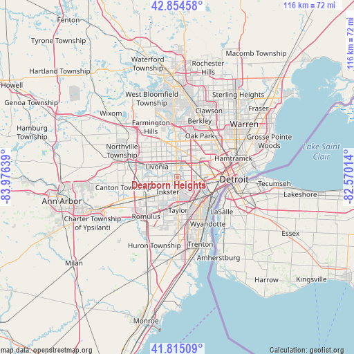
Dearborn Heights GPS coordinates[2]
42° 20' 13.128" North, 83° 16' 23.736" West
| Map corner | latitude | longitude |
|---|---|---|
| Upper-left | 42.85458°, | -83.97639° |
| Center: | 42.33698°, | -83.27326° |
| Lower-right: | 41.81509°, | -82.57014° |
| Map W x H: | 115.6×115.6 km | = 71.8×71.8mi |
| max Lat: | 71.29058° ⇑21.6% North |
| Dearborn Heights: | 42.33698° |
| min Lat: | ⇓78.4% South 19.06759° |
| min Long | Dearborn Height | max Long |
| -171.73463° | -83.27326° | -66.98998° |
| W 61.2%⇐ | ⇒38.8% E |
Elevation
Elevation of Dearborn Heights is 190 m = 623 ft, and this is 104.8 m = 344 ft below average elevation for this country.
| Max E: |
3189 m = 10463 ft | 52.2% |
| Avg. | 294.8 m = 967 ft | |
| Dearborn Heights | 190 m = 623 ft | |
Min E: |
-60 m = -197 ft | 47.8% |
See also: Dearborn Heights elevation on elevation.city.
Geographical zone
Dearborn Heights is located in North temperate zone (between Tropic of Cancer and the Arctic Circle). Distance of this Northern Tropic circle is 2101.5 km =1305.8 mi to South.| Distance of | km | miles | from Dearborn Heights |
|---|---|---|---|
| North Pole | 5299.6 | 3293 | to North |
| Arctic Circle | 2693.7 | 1673.8 | to North |
| Tropic Cancer | 2101.5 | 1305.8 | to South |
| Equator | 4707.4 | 2925 | to South |


Nearby cities:
15 places around Dearborn Heights: (largest is in red/bold)
• Allen Park
10.2 km =6.3 mi,  149°
149°
• Dearborn
8.1 km =5 mi,  101°
101°
• Ecorse
14.7 km =9.1 mi,  134°
134°
• Garden City
4.9 km =3 mi,  255°
255°
• Inkster
5.6 km =3.5 mi,  212°
212°
• Lincoln Park
12.4 km =7.7 mi,  140°
140°
• Livonia
7.4 km =4.6 mi,  298°
298°
• Melvindale
10.1 km =6.3 mi, 126°
• Oak Park
15.5 km =9.6 mi,  28°
28°
• Redford
5.5 km =3.4 mi,  339°
339°
• River Rouge
13.4 km =8.3 mi,  121°
121°
• Southgate
15.2 km =9.4 mi, 154°
• Taylor
10.7 km =6.6 mi,  178°
178°
• Wayne
11.2 km =7 mi,  236°
236°
• Westland
10.5 km =6.5 mi, 262°
Sources, notices
• [Note1] Compared only with cities in United States existing in our database
• [Src1] Map data: © OpenStreetMap contributors (CC-BY-SA)
• [Src2] Other city data from geonames.org with taken over terms of usage.
• [Src3] Geographical zone / Annual Mean Temperature by Robert A. Rohde @ Wikipedia
