Warren geodata
Warren (Michigan) is a populated place; located in United States in America/Detroit (GMT-4) time zone. With population of 134,056 people, there are 223 cities with bigger population in this country. Compared to other cities in United States, 79.7% of cities are located further ↓South; 62% of cities are located further ←West and 50.5% of cities have higher elevation than Warren. Note1


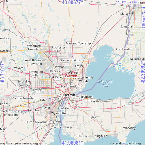
Warren GPS coordinates[2]
42° 29' 25.584" North, 83° 0' 46.944" West
| Map corner | latitude | longitude |
|---|---|---|
| Upper-left | 43.00677°, | -83.71617° |
| Center: | 42.49044°, | -83.01304° |
| Lower-right: | 41.96981°, | -82.30992° |
| Map W x H: | 115.3×115.3 km | = 71.6×71.6mi |
| max Lat: | 71.29058° ⇑20.3% North |
| Warren: | 42.49044° |
| min Lat: | ⇓79.7% South 19.06759° |
| min Long | Warren | max Long |
| -171.73463° | -83.01304° | -66.98998° |
| W 62%⇐ | ⇒38% E |
Elevation
Elevation of Warren is 196 m = 643 ft, and this is 98.8 m = 324 ft below average elevation for this country.
| Max E: |
3189 m = 10463 ft | 50.5% |
| Avg. | 294.8 m = 967 ft | |
| Warren | 196 m = 643 ft | |
Min E: |
-60 m = -197 ft | 49.5% |
See also: Warren elevation on elevation.city.
Geographical zone
Warren is located in North temperate zone (between Tropic of Cancer and the Arctic Circle). Distance of this Northern Tropic circle is 2118.6 km =1316.4 mi to South.| Distance of | km | miles | from Warren |
|---|---|---|---|
| North Pole | 5282.6 | 3282.5 | to North |
| Arctic Circle | 2676.7 | 1663.2 | to North |
| Tropic Cancer | 2118.6 | 1316.4 | to South |
| Equator | 4724.5 | 2935.7 | to South |


Nearby cities:
15 places around Warren: (largest is in red/bold)
• Center Line
1.3 km =0.8 mi,  243°
243°
• Eastpointe
5.3 km =3.3 mi,  117°
117°
• Ferndale
10.5 km =6.5 mi,  251°
251°
• Fraser
7.5 km =4.7 mi,  43°
43°
• Grosse Pointe Woods
10.1 km =6.3 mi, 120°
• Hamtramck
11.3 km =7 mi,  195°
195°
• Harper Woods
9.7 km =6 mi,  131°
131°
• Hazel Park
8.1 km =5 mi, 247°
• Highland Park
11.7 km =7.3 mi,  216°
216°
• Madison Heights
7.6 km =4.7 mi,  266°
266°
• Pleasant Ridge
10.8 km =6.7 mi,  258°
258°
• Roseville
6.3 km =3.9 mi,  83°
83°
• Royal Oak
10.8 km =6.7 mi, 269°
• Saint Clair Shores
10.2 km =6.3 mi,  85°
85°
• Sterling Heights
10.1 km =6.3 mi,  351°
351°
Sources, notices
• [Note1] Compared only with cities in United States existing in our database
• [Src1] Map data: © OpenStreetMap contributors (CC-BY-SA)
• [Src2] Other city data from geonames.org with taken over terms of usage.
• [Src3] Geographical zone / Annual Mean Temperature by Robert A. Rohde @ Wikipedia
