Roseville geodata
Roseville (Michigan) is a populated place; located in United States in America/Detroit (GMT-4) time zone. With population of 47,637 people, there are 1010 cities with bigger population in this country. Compared to other cities in United States, 79.8% of cities are located further ↓South; 62.2% of cities are located further ←West and 52.5% of cities have higher elevation than Roseville. Note1


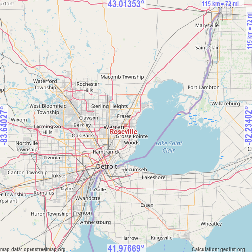
Roseville GPS coordinates[2]
42° 29' 50.136" North, 82° 56' 13.704" West
| Map corner | latitude | longitude |
|---|---|---|
| Upper-left | 43.01353°, | -83.64027° |
| Center: | 42.49726°, | -82.93714° |
| Lower-right: | 41.97669°, | -82.23402° |
| Map W x H: | 115.3×115.3 km | = 71.6×71.6mi |
| max Lat: | 71.29058° ⇑20.2% North |
| Roseville: | 42.49726° |
| min Lat: | ⇓79.8% South 19.06759° |
| min Long | Roseville | max Long |
| -171.73463° | -82.93714° | -66.98998° |
| W 62.2%⇐ | ⇒37.8% E |
Elevation
Elevation of Roseville is 189 m = 620 ft, and this is 105.8 m = 347 ft below average elevation for this country.
| Max E: |
3189 m = 10463 ft | 52.5% |
| Avg. | 294.8 m = 967 ft | |
| Roseville | 189 m = 620 ft | |
Min E: |
-60 m = -197 ft | 47.5% |
See also: Roseville elevation on elevation.city.
Geographical zone
Roseville is located in North temperate zone (between Tropic of Cancer and the Arctic Circle). Distance of this Northern Tropic circle is 2119.3 km =1316.9 mi to South.| Distance of | km | miles | from Roseville |
|---|---|---|---|
| North Pole | 5281.8 | 3282 | to North |
| Arctic Circle | 2675.9 | 1662.7 | to North |
| Tropic Cancer | 2119.3 | 1316.9 | to South |
| Equator | 4725.3 | 2936.2 | to South |


Nearby cities:
15 places around Roseville: (largest is in red/bold)
• Center Line
7.5 km =4.7 mi,  259°
259°
• Clinton Township
10.1 km =6.3 mi,  8°
8°
• Eastpointe
3.5 km =2.2 mi,  205°
205°
• Fraser
4.8 km =3 mi,  347°
347°
• Grosse Pointe
12.5 km =7.8 mi,  170°
170°
• Grosse Pointe Farms
10.5 km =6.5 mi,  159°
159°
• Grosse Pointe Park
13.5 km =8.4 mi,  180°
180°
• Grosse Pointe Shores
8.4 km =5.2 mi,  143°
143°
• Grosse Pointe Woods
6.5 km =4 mi, 157°
• Harper Woods
7.2 km =4.5 mi, 171°
• Madison Heights
13.8 km =8.6 mi, 264°
• Mount Clemens
12.1 km =7.5 mi,  23°
23°
• Saint Clair Shores
4 km =2.5 mi,  90°
90°
• Sterling Heights
12 km =7.5 mi,  320°
320°
• Warren
6.3 km =3.9 mi, 263°
Sources, notices
• [Note1] Compared only with cities in United States existing in our database
• [Src1] Map data: © OpenStreetMap contributors (CC-BY-SA)
• [Src2] Other city data from geonames.org with taken over terms of usage.
• [Src3] Geographical zone / Annual Mean Temperature by Robert A. Rohde @ Wikipedia
