Saint Clair Shores geodata
Saint Clair Shores (Michigan) is a populated place; located in United States in America/Detroit (GMT-4) time zone. With population of 59,715 people, there are 754 cities with bigger population in this country. Compared to other cities in United States, 79.8% of cities are located further ↓South; 62.3% of cities are located further ←West and 55.5% of cities have higher elevation than Saint Clair Shores. Note1
Administrative division(s):
- Level 1: Michigan
- Level 2: Macomb County
- Level 3: City of Saint Clair Shores


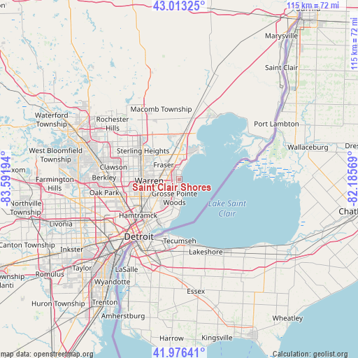
Saint Clair Shores GPS coordinates[2]
42° 29' 49.128" North, 82° 53' 19.716" West
| Map corner | latitude | longitude |
|---|---|---|
| Upper-left | 43.01325°, | -83.59194° |
| Center: | 42.49698°, | -82.88881° |
| Lower-right: | 41.97641°, | -82.18569° |
| Map W x H: | 115.3×115.3 km | = 71.6×71.6mi |
| max Lat: | 71.29058° ⇑20.2% North |
| Saint Clair Shores: | 42.49698° |
| min Lat: | ⇓79.8% South 19.06759° |
| min Long | Saint Clair Sho | max Long |
| -171.73463° | -82.88881° | -66.98998° |
| W 62.3%⇐ | ⇒37.7% E |
Elevation
Elevation of Saint Clair Shores is 178 m = 584 ft, and this is 116.8 m = 383 ft below average elevation for this country.
| Max E: |
3189 m = 10463 ft | 55.5% |
| Avg. | 294.8 m = 967 ft | |
| Saint Clair Shores | 178 m = 584 ft | |
Min E: |
-60 m = -197 ft | 44.5% |
See also: Saint Clair Shores elevation on elevation.city.
Geographical zone
Saint Clair Shores is located in North temperate zone (between Tropic of Cancer and the Arctic Circle). Distance of this Northern Tropic circle is 2119.3 km =1316.9 mi to South.| Distance of | km | miles | from Saint Clair Shores |
|---|---|---|---|
| North Pole | 5281.8 | 3282 | to North |
| Arctic Circle | 2676 | 1662.8 | to North |
| Tropic Cancer | 2119.3 | 1316.9 | to South |
| Equator | 4725.2 | 2936.1 | to South |


Nearby cities:
15 places around Saint Clair Shores: (largest is in red/bold)
• Center Line
11.5 km =7.1 mi,  263°
263°
• Clinton Township
10.3 km =6.4 mi,  345°
345°
• Eastpointe
6.3 km =3.9 mi,  239°
239°
• Fraser
6.8 km =4.2 mi,  313°
313°
• Grosse Pointe
12.5 km =7.8 mi,  188°
188°
• Grosse Pointe Farms
9.8 km =6.1 mi,  181°
181°
• Grosse Pointe Park
14 km =8.7 mi,  196°
196°
• Grosse Pointe Shores
6.8 km =4.2 mi,  171°
171°
• Grosse Pointe Woods
6.1 km =3.8 mi, 194°
• Hamtramck
17.6 km =10.9 mi,  228°
228°
• Harper Woods
7.7 km =4.8 mi, 202°
• Mount Clemens
11.2 km =7 mi,  4°
4°
• Roseville
4 km =2.5 mi,  270°
270°
• Sterling Heights
14.8 km =9.2 mi, 308°
• Warren
10.2 km =6.3 mi, 265°
Sources, notices
• [Note1] Compared only with cities in United States existing in our database
• [Src1] Map data: © OpenStreetMap contributors (CC-BY-SA)
• [Src2] Other city data from geonames.org with taken over terms of usage.
• [Src3] Geographical zone / Annual Mean Temperature by Robert A. Rohde @ Wikipedia
