Amboy geodata
Amboy (Minnesota) is a populated place; located in United States in America/Chicago (GMT-5) time zone. With population of 522 people, there are 20606 cities with bigger population in this country. Compared to other cities in United States, 88% of cities are located further ↓South; 69% of cities are located further →East and 76% of cities have lower elevation than Amboy. Note1


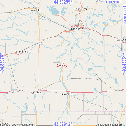
Amboy GPS coordinates[2]
43° 53' 16.836" North, 94° 9' 23.868" West
| Map corner | latitude | longitude |
|---|---|---|
| Upper-left | 44.39259°, | -94.85976° |
| Center: | 43.88801°, | -94.15663° |
| Lower-right: | 43.37912°, | -93.45351° |
| Map W x H: | 112.7×112.7 km | = 70×70mi |
| max Lat: | 71.29058° ⇑12% North |
| Amboy: | 43.88801° |
| min Lat: | ⇓88% South 19.06759° |
| min Long | Amboy | max Long |
| -171.73463° | -94.15663° | -66.98998° |
| W 31%⇐ | ⇒69% E |
Elevation
Elevation of Amboy is 320 m = 1050 ft, and this is 25.2 m = 83 ft above average elevation for this country.
| Max E: |
3189 m = 10463 ft | 24% |
| Amboy | 320 m 1050 ft | |
| Avg. | 294.8 m = 967 ft | |
Min E: |
-60 m = -197 ft | 76% |
See also: United States elevation on elevation.city.
Geographical zone
Amboy is located in North temperate zone (between Tropic of Cancer and the Arctic Circle). Distance of this Northern Tropic circle is 2274 km =1413 mi to South.| Distance of | km | miles | from Amboy |
|---|---|---|---|
| North Pole | 5127.2 | 3185.9 | to North |
| Arctic Circle | 2521.3 | 1566.7 | to North |
| Tropic Cancer | 2274 | 1413 | to South |
| Equator | 4879.9 | 3032.2 | to South |


Nearby cities:
15 places around Amboy: (largest is in red/bold)
• Blue Earth
28.2 km =17.5 mi,  171°
171°
• Eagle Lake
37.9 km =23.5 mi,  35°
35°
• Fairmont
35.8 km =22.2 mi,  222°
222°
• Good Thunder
14.9 km =9.3 mi,  29°
29°
• Lake Crystal
24.7 km =15.3 mi,  348°
348°
• Madelia
27.7 km =17.2 mi,  310°
310°
• Mankato
32.4 km =20.1 mi,  21°
21°
• Mapleton
16.7 km =10.4 mi,  74°
74°
• Minnesota Lake
26.5 km =16.5 mi,  101°
101°
• North Mankato
33.2 km =20.6 mi, 17°
• Saint Clair
32.2 km =20 mi,  47°
47°
• Saint James
39.1 km =24.3 mi,  285°
285°
• Truman
23.5 km =14.6 mi,  253°
253°
• Wells
37.8 km =23.5 mi,  114°
114°
• Winnebago
13.4 km =8.3 mi,  183°
183°
Sources, notices
• [Note1] Compared only with cities in United States existing in our database
• [Src1] Map data: © OpenStreetMap contributors (CC-BY-SA)
• [Src2] Other city data from geonames.org with taken over terms of usage.
• [Src3] Geographical zone / Annual Mean Temperature by Robert A. Rohde @ Wikipedia
