Mankato geodata
Mankato (Minnesota) is a seat of a second-order administrative division; located in United States in America/Chicago (GMT-5) time zone. With population of 41,044 people, there are 1172 cities with bigger population in this country. Compared to other cities in United States, 89% of cities are located further ↓South; 68.7% of cities are located further →East and 61.2% of cities have lower elevation than Mankato. Note1


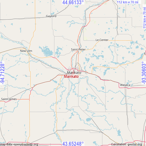
Mankato GPS coordinates[2]
44° 9' 32.616" North, 94° 0' 32.94" West
| Map corner | latitude | longitude |
|---|---|---|
| Upper-left | 44.66133°, | -94.71228° |
| Center: | 44.15906°, | -94.00915° |
| Lower-right: | 43.65248°, | -93.30603° |
| Map W x H: | 112.2×112.2 km | = 69.7×69.7mi |
| max Lat: | 71.29058° ⇑11% North |
| Mankato: | 44.15906° |
| min Lat: | ⇓89% South 19.06759° |
| min Long | Mankato | max Long |
| -171.73463° | -94.00915° | -66.98998° |
| W 31.3%⇐ | ⇒68.7% E |
Elevation
Elevation of Mankato is 245 m = 804 ft, and this is 49.8 m = 163 ft below average elevation for this country.
| Max E: |
3189 m = 10463 ft | 38.8% |
| Avg. | 294.8 m = 967 ft | |
| Mankato | 245 m = 804 ft | |
Min E: |
-60 m = -197 ft | 61.2% |
See also: Mankato elevation on elevation.city.
Geographical zone
Mankato is located in North temperate zone (between Tropic of Cancer and the Arctic Circle). Distance of this Northern Tropic circle is 2304.1 km =1431.7 mi to South.| Distance of | km | miles | from Mankato |
|---|---|---|---|
| North Pole | 5097 | 3167.1 | to North |
| Arctic Circle | 2491.1 | 1547.9 | to North |
| Tropic Cancer | 2304.1 | 1431.7 | to South |
| Equator | 4910 | 3050.9 | to South |


Nearby cities:
15 places around Mankato: (largest is in red/bold)
• Amboy
32.4 km =20.1 mi,  201°
201°
• Cleveland
23 km =14.3 mi,  36°
36°
• Courtland
29 km =18 mi,  294°
294°
• Eagle Lake
10.2 km =6.3 mi,  86°
86°
• Elysian
27.1 km =16.8 mi,  80°
80°
• Good Thunder
17.8 km =11.1 mi,  194°
194°
• Janesville
24.5 km =15.2 mi,  101°
101°
• Kasota
15.2 km =9.4 mi,  13°
13°
• Lake Crystal
17.8 km =11.1 mi,  250°
250°
• Madison Lake
16.2 km =10.1 mi,  71°
71°
• Mapleton
25.9 km =16.1 mi,  170°
170°
• Nicollet
19.3 km =12 mi,  312°
312°
• North Mankato
2.5 km =1.6 mi, 308°
• Saint Clair
14.8 km =9.2 mi,  125°
125°
• Saint Peter
18.7 km =11.6 mi, 12°
Sources, notices
• [Note1] Compared only with cities in United States existing in our database
• [Src1] Map data: © OpenStreetMap contributors (CC-BY-SA)
• [Src2] Other city data from geonames.org with taken over terms of usage.
• [Src3] Geographical zone / Annual Mean Temperature by Robert A. Rohde @ Wikipedia
