Brownton geodata
Brownton (Minnesota) is a populated place; located in United States in America/Chicago (GMT-5) time zone. With population of 738 people, there are 18324 cities with bigger population in this country. Compared to other cities in United States, 91.3% of cities are located further ↓South; 69.5% of cities are located further →East and 75.3% of cities have lower elevation than Brownton. Note1


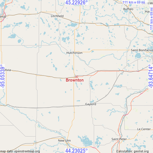
Brownton GPS coordinates[2]
44° 43' 54.876" North, 94° 21' 0.936" West
| Map corner | latitude | longitude |
|---|---|---|
| Upper-left | 45.22926°, | -95.05339° |
| Center: | 44.73191°, | -94.35026° |
| Lower-right: | 44.23025°, | -93.64714° |
| Map W x H: | 111.1×111.1 km | = 69×69mi |
| max Lat: | 71.29058° ⇑8.7% North |
| Brownton: | 44.73191° |
| min Lat: | ⇓91.3% South 19.06759° |
| min Long | Brownton | max Long |
| -171.73463° | -94.35026° | -66.98998° |
| W 30.5%⇐ | ⇒69.5% E |
Elevation
Elevation of Brownton is 315 m = 1033 ft, and this is 20.2 m = 66 ft above average elevation for this country.
| Max E: |
3189 m = 10463 ft | 24.7% |
| Brownton | 315 m 1033 ft | |
| Avg. | 294.8 m = 967 ft | |
Min E: |
-60 m = -197 ft | 75.3% |
See also: United States elevation on elevation.city.
Geographical zone
Brownton is located in North temperate zone (between Tropic of Cancer and the Arctic Circle). Distance of this Northern Tropic circle is 2367.8 km =1471.3 mi to South.| Distance of | km | miles | from Brownton |
|---|---|---|---|
| North Pole | 5033.3 | 3127.5 | to North |
| Arctic Circle | 2427.5 | 1508.4 | to North |
| Tropic Cancer | 2367.8 | 1471.3 | to South |
| Equator | 4973.7 | 3090.5 | to South |


Nearby cities:
15 places around Brownton: (largest is in red/bold)
• Arlington
25.4 km =15.8 mi,  122°
122°
• Buffalo Lake
21.1 km =13.1 mi,  271°
271°
• Gaylord
22.4 km =13.9 mi,  152°
152°
• Gibbon
26.1 km =16.2 mi,  212°
212°
• Glencoe
16.2 km =10.1 mi,  75°
75°
• Green Isle
27.7 km =17.2 mi,  102°
102°
• Hamburg
30.3 km =18.8 mi,  89°
89°
• Hector
28.9 km =18 mi, 272°
• Hutchinson
17.4 km =10.8 mi,  354°
354°
• Lester Prairie
29.6 km =18.4 mi,  55°
55°
• Norwood (historical)
33.6 km =20.9 mi, 83°
• Norwood Young America
34.2 km =21.3 mi, 82°
• Silver Lake
22.6 km =14 mi,  32°
32°
• Stewart
10.7 km =6.6 mi, 265°
• Winthrop
21 km =13 mi,  183°
183°
Sources, notices
• [Note1] Compared only with cities in United States existing in our database
• [Src1] Map data: © OpenStreetMap contributors (CC-BY-SA)
• [Src2] Other city data from geonames.org with taken over terms of usage.
• [Src3] Geographical zone / Annual Mean Temperature by Robert A. Rohde @ Wikipedia
