Arlington geodata
Arlington (Minnesota) is a populated place; located in United States in America/Chicago (GMT-5) time zone. With population of 2,169 people, there are 11417 cities with bigger population in this country. Compared to other cities in United States, 90.9% of cities are located further ↓South; 68.8% of cities are located further →East and 73.5% of cities have lower elevation than Arlington. Note1


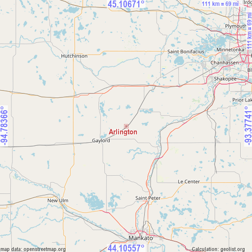
Arlington GPS coordinates[2]
44° 36' 29.88" North, 94° 4' 49.908" West
| Map corner | latitude | longitude |
|---|---|---|
| Upper-left | 45.10671°, | -94.78366° |
| Center: | 44.6083°, | -94.08053° |
| Lower-right: | 44.10557°, | -93.37741° |
| Map W x H: | 111.3×111.3 km | = 69.2×69.2mi |
| max Lat: | 71.29058° ⇑9.1% North |
| Arlington: | 44.6083° |
| min Lat: | ⇓90.9% South 19.06759° |
| min Long | Arlington | max Long |
| -171.73463° | -94.08053° | -66.98998° |
| W 31.2%⇐ | ⇒68.8% E |
Elevation
Elevation of Arlington is 304 m = 997 ft, and this is 9.2 m = 30 ft above average elevation for this country.
| Max E: |
3189 m = 10463 ft | 26.5% |
| Arlington | 304 m 997 ft | |
| Avg. | 294.8 m = 967 ft | |
Min E: |
-60 m = -197 ft | 73.5% |
See also: United States elevation on elevation.city.
Geographical zone
Arlington is located in North temperate zone (between Tropic of Cancer and the Arctic Circle). Distance of this Northern Tropic circle is 2354.1 km =1462.8 mi to South.| Distance of | km | miles | from Arlington |
|---|---|---|---|
| North Pole | 5047.1 | 3136.1 | to North |
| Arctic Circle | 2441.2 | 1516.9 | to North |
| Tropic Cancer | 2354.1 | 1462.8 | to South |
| Equator | 4960 | 3082 | to South |


Nearby cities:
15 places around Arlington: (largest is in red/bold)
• Belle Plaine
24.7 km =15.3 mi,  86°
86°
• Brownton
25.4 km =15.8 mi,  302°
302°
• Cologne
29.8 km =18.5 mi,  52°
52°
• Gaylord
12.7 km =7.9 mi,  240°
240°
• Glencoe
18.7 km =11.6 mi,  342°
342°
• Green Isle
9.7 km =6 mi,  35°
35°
• Hamburg
16.5 km =10.3 mi,  32°
32°
• Henderson
16.3 km =10.1 mi,  123°
123°
• Le Sueur
20.9 km =13 mi,  141°
141°
• Lester Prairie
30.8 km =19.1 mi,  5°
5°
• Norwood (historical)
21.5 km =13.4 mi, 34°
• Norwood Young America
22.3 km =13.9 mi, 34°
• Saint Peter
33.1 km =20.6 mi,  162°
162°
• Winthrop
23.8 km =14.8 mi,  252°
252°
• Young America (historical)
23.5 km =14.6 mi, 34°
Sources, notices
• [Note1] Compared only with cities in United States existing in our database
• [Src1] Map data: © OpenStreetMap contributors (CC-BY-SA)
• [Src2] Other city data from geonames.org with taken over terms of usage.
• [Src3] Geographical zone / Annual Mean Temperature by Robert A. Rohde @ Wikipedia
