Cloquet geodata
Cloquet (Minnesota) is a populated place; located in United States in America/Chicago (GMT-5) time zone. With population of 12,075 people, there are 3878 cities with bigger population in this country. Compared to other cities in United States, 96.2% of cities are located further ↓South; 65.1% of cities are located further →East and 81.1% of cities have lower elevation than Cloquet. Note1


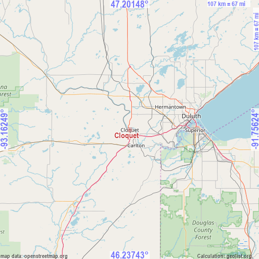
Cloquet GPS coordinates[2]
46° 43' 17.796" North, 92° 27' 33.696" West
| Map corner | latitude | longitude |
|---|---|---|
| Upper-left | 47.20148°, | -93.16249° |
| Center: | 46.72161°, | -92.45936° |
| Lower-right: | 46.23743°, | -91.75624° |
| Map W x H: | 107.2×107.2 km | = 66.6×66.6mi |
| max Lat: | 71.29058° ⇑3.8% North |
| Cloquet: | 46.72161° |
| min Lat: | ⇓96.2% South 19.06759° |
| min Long | Cloquet | max Long |
| -171.73463° | -92.45936° | -66.98998° |
| W 34.9%⇐ | ⇒65.1% E |
Elevation
Elevation of Cloquet is 366 m = 1201 ft, and this is 71.2 m = 234 ft above average elevation for this country.
| Max E: |
3189 m = 10463 ft | 18.9% |
| Cloquet | 366 m 1201 ft | |
| Avg. | 294.8 m = 967 ft | |
Min E: |
-60 m = -197 ft | 81.1% |
See also: United States elevation on elevation.city.
Geographical zone
Cloquet is located in North temperate zone (between Tropic of Cancer and the Arctic Circle). Distance of this North polar circle is 2206.2 km =1370.9 mi to North.| Distance of | km | miles | from Cloquet |
|---|---|---|---|
| North Pole | 4812.1 | 2990.1 | to North |
| Arctic Circle | 2206.2 | 1370.9 | to North |
| Tropic Cancer | 2589 | 1608.7 | to South |
| Equator | 5195 | 3228 | to South |


Nearby cities:
15 places around Cloquet: (largest is in red/bold)
• Arnold
33.2 km =20.6 mi,  57°
57°
• Barnum
30 km =18.6 mi,  215°
215°
• Carlton
6.9 km =4.3 mi,  157°
157°
• Duluth
27.7 km =17.2 mi,  75°
75°
• Esko
7.5 km =4.7 mi,  103°
103°
• Floodwood
41.9 km =26 mi,  303°
303°
• Hermantown
19.3 km =12 mi, 60°
• Lake Nebagamon
62.4 km =38.8 mi,  111°
111°
• Moose Lake
37.7 km =23.4 mi, 217°
• Poplar
52.7 km =32.7 mi, 106°
• Proctor
18 km =11.2 mi, 80°
• Scanlon
2.9 km =1.8 mi,  125°
125°
• Solon Springs
63.6 km =39.5 mi, 130°
• Superior
27.1 km =16.8 mi,  90°
90°
• Superior Village
28 km =17.4 mi, 104°
Sources, notices
• [Note1] Compared only with cities in United States existing in our database
• [Src1] Map data: © OpenStreetMap contributors (CC-BY-SA)
• [Src2] Other city data from geonames.org with taken over terms of usage.
• [Src3] Geographical zone / Annual Mean Temperature by Robert A. Rohde @ Wikipedia
