Superior Village geodata
Superior Village (Wisconsin) is a populated place; located in United States in America/Chicago (GMT-5) time zone. With population of 558 people, there are 20177 cities with bigger population in this country. Compared to other cities in United States, 96.1% of cities are located further ↓South; 64.3% of cities are located further →East and 51.2% of cities have lower elevation than Superior Village. Note1


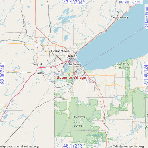
Superior Village GPS coordinates[2]
46° 39' 24.804" North, 92° 6' 15.696" West
| Map corner | latitude | longitude |
|---|---|---|
| Upper-left | 47.13734°, | -92.80749° |
| Center: | 46.65689°, | -92.10436° |
| Lower-right: | 46.17213°, | -91.40124° |
| Map W x H: | 107.3×107.3 km | = 66.7×66.7mi |
| max Lat: | 71.29058° ⇑3.9% North |
| Superior Village: | 46.65689° |
| min Lat: | ⇓96.1% South 19.06759° |
| min Long | Superior Villag | max Long |
| -171.73463° | -92.10436° | -66.98998° |
| W 35.7%⇐ | ⇒64.3% E |
Elevation
Elevation of Superior Village is 203 m = 666 ft, and this is 91.8 m = 301 ft below average elevation for this country.
| Max E: |
3189 m = 10463 ft | 48.8% |
| Avg. | 294.8 m = 967 ft | |
| Superior Village | 203 m = 666 ft | |
Min E: |
-60 m = -197 ft | 51.2% |
See also: United States elevation on elevation.city.
Geographical zone
Superior Village is located in North temperate zone (between Tropic of Cancer and the Arctic Circle). Distance of this North polar circle is 2213.4 km =1375.3 mi to North.| Distance of | km | miles | from Superior Village |
|---|---|---|---|
| North Pole | 4819.3 | 2994.6 | to North |
| Arctic Circle | 2213.4 | 1375.3 | to North |
| Tropic Cancer | 2581.8 | 1604.3 | to South |
| Equator | 5187.8 | 3223.5 | to South |


Nearby cities:
15 places around Superior Village: (largest is in red/bold)
• Arnold
24.9 km =15.5 mi,  2°
2°
• Barnum
47.8 km =29.7 mi,  249°
249°
• Carlton
24.5 km =15.2 mi,  271°
271°
• Cloquet
28 km =17.4 mi,  284°
284°
• Duluth
14.1 km =8.8 mi,  359°
359°
• Esko
20.5 km =12.7 mi,  285°
285°
• Hermantown
19.6 km =12.2 mi,  328°
328°
• Iron River
54.2 km =33.7 mi,  100°
100°
• Lake Nebagamon
34.7 km =21.6 mi,  117°
117°
• Poplar
24.7 km =15.3 mi,  109°
109°
• Proctor
13.6 km =8.5 mi,  317°
317°
• Scanlon
25.3 km =15.7 mi, 282°
• Solon Springs
40.1 km =24.9 mi,  147°
147°
• Superior
7.1 km =4.4 mi, 0°
• Two Harbors
52.4 km =32.6 mi,  39°
39°
Sources, notices
• [Note1] Compared only with cities in United States existing in our database
• [Src1] Map data: © OpenStreetMap contributors (CC-BY-SA)
• [Src2] Other city data from geonames.org with taken over terms of usage.
• [Src3] Geographical zone / Annual Mean Temperature by Robert A. Rohde @ Wikipedia
