Duluth geodata
Duluth (Minnesota) is a seat of a second-order administrative division; located in United States in America/Chicago (GMT-5) time zone. With population of 86,110 people, there are 447 cities with bigger population in this country. Compared to other cities in United States, 96.3% of cities are located further ↓South; 64.3% of cities are located further →East and 54.4% of cities have lower elevation than Duluth. Note1


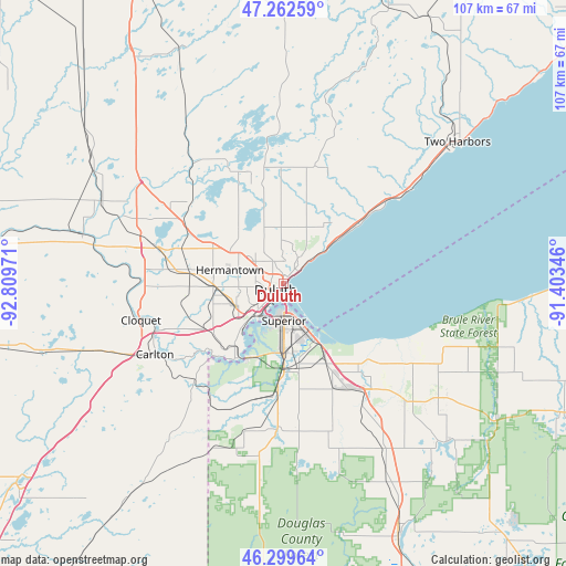
Duluth GPS coordinates[2]
46° 46' 59.772" North, 92° 6' 23.688" West
| Map corner | latitude | longitude |
|---|---|---|
| Upper-left | 47.26259°, | -92.80971° |
| Center: | 46.78327°, | -92.10658° |
| Lower-right: | 46.29964°, | -91.40346° |
| Map W x H: | 107.1×107.1 km | = 66.5×66.5mi |
| max Lat: | 71.29058° ⇑3.7% North |
| Duluth: | 46.78327° |
| min Lat: | ⇓96.3% South 19.06759° |
| min Long | Duluth | max Long |
| -171.73463° | -92.10658° | -66.98998° |
| W 35.7%⇐ | ⇒64.3% E |
Elevation
Elevation of Duluth is 216 m = 709 ft, and this is 78.8 m = 259 ft below average elevation for this country.
| Max E: |
3189 m = 10463 ft | 45.6% |
| Avg. | 294.8 m = 967 ft | |
| Duluth | 216 m = 709 ft | |
Min E: |
-60 m = -197 ft | 54.4% |
See also: Duluth elevation on elevation.city.
Geographical zone
Duluth is located in North temperate zone (between Tropic of Cancer and the Arctic Circle). Distance of this North polar circle is 2199.4 km =1366.6 mi to North.| Distance of | km | miles | from Duluth |
|---|---|---|---|
| North Pole | 4805.2 | 2985.8 | to North |
| Arctic Circle | 2199.4 | 1366.6 | to North |
| Tropic Cancer | 2595.9 | 1613 | to South |
| Equator | 5201.8 | 3232.2 | to South |


Nearby cities:
15 places around Duluth: (largest is in red/bold)
• Arnold
10.8 km =6.7 mi,  6°
6°
• Barnum
54.3 km =33.7 mi,  234°
234°
• Carlton
27.7 km =17.2 mi,  241°
241°
• Cloquet
27.7 km =17.2 mi,  255°
255°
• Esko
21.4 km =13.3 mi,  246°
246°
• Hermantown
10.4 km =6.5 mi,  284°
284°
• Iron River
58.6 km =36.4 mi,  114°
114°
• Lake Nebagamon
43.1 km =26.8 mi,  133°
133°
• Poplar
32.3 km =20.1 mi, 133°
• Proctor
9.9 km =6.2 mi, 246°
• Scanlon
25.9 km =16.1 mi, 250°
• Solon Springs
52.5 km =32.6 mi,  155°
155°
• Superior
7 km =4.3 mi,  178°
178°
• Superior Village
14.1 km =8.8 mi, 179°
• Two Harbors
42.5 km =26.4 mi,  51°
51°
Sources, notices
• [Note1] Compared only with cities in United States existing in our database
• [Src1] Map data: © OpenStreetMap contributors (CC-BY-SA)
• [Src2] Other city data from geonames.org with taken over terms of usage.
• [Src3] Geographical zone / Annual Mean Temperature by Robert A. Rohde @ Wikipedia
