Courtland geodata
Courtland (Minnesota) is a populated place; located in United States in America/Chicago (GMT-5) time zone. With population of 653 people, there are 19151 cities with bigger population in this country. Compared to other cities in United States, 89.5% of cities are located further ↓South; 69.4% of cities are located further →East and 69% of cities have lower elevation than Courtland. Note1


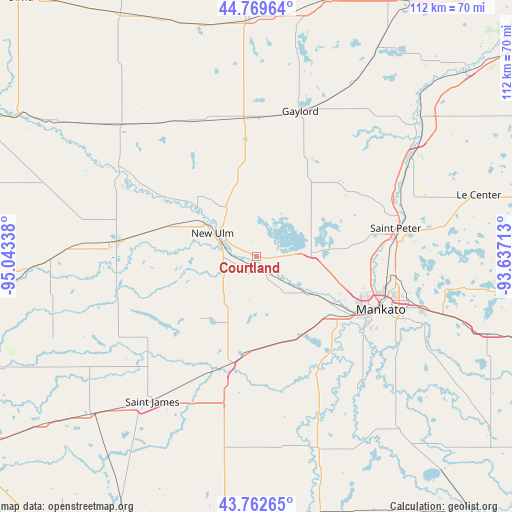
Courtland GPS coordinates[2]
44° 16' 5.88" North, 94° 20' 24.9" West
| Map corner | latitude | longitude |
|---|---|---|
| Upper-left | 44.76964°, | -95.04338° |
| Center: | 44.2683°, | -94.34025° |
| Lower-right: | 43.76265°, | -93.63713° |
| Map W x H: | 112×112 km | = 69.6×69.6mi |
| max Lat: | 71.29058° ⇑10.5% North |
| Courtland: | 44.2683° |
| min Lat: | ⇓89.5% South 19.06759° |
| min Long | Courtland | max Long |
| -171.73463° | -94.34025° | -66.98998° |
| W 30.6%⇐ | ⇒69.4% E |
Elevation
Elevation of Courtland is 281 m = 922 ft, and this is 13.8 m = 45 ft below average elevation for this country.
| Max E: |
3189 m = 10463 ft | 31% |
| Avg. | 294.8 m = 967 ft | |
| Courtland | 281 m = 922 ft | |
Min E: |
-60 m = -197 ft | 69% |
See also: United States elevation on elevation.city.
Geographical zone
Courtland is located in North temperate zone (between Tropic of Cancer and the Arctic Circle). Distance of this Northern Tropic circle is 2316.3 km =1439.3 mi to South.| Distance of | km | miles | from Courtland |
|---|---|---|---|
| North Pole | 5084.9 | 3159.6 | to North |
| Arctic Circle | 2479 | 1540.4 | to North |
| Tropic Cancer | 2316.3 | 1439.3 | to South |
| Equator | 4922.2 | 3058.5 | to South |


Nearby cities:
15 places around Courtland: (largest is in red/bold)
• Eagle Lake
38.3 km =23.8 mi,  107°
107°
• Gaylord
33.1 km =20.6 mi,  16°
16°
• Gibbon
33 km =20.5 mi,  333°
333°
• Good Thunder
36.6 km =22.7 mi,  143°
143°
• Kasota
30 km =18.6 mi,  84°
84°
• Lake Crystal
20.5 km =12.7 mi,  151°
151°
• Madelia
25 km =15.5 mi,  194°
194°
• Mankato
29 km =18 mi, 114°
• New Ulm
10.8 km =6.7 mi,  297°
297°
• Nicollet
12.2 km =7.6 mi,  85°
85°
• North Mankato
26.6 km =16.5 mi, 113°
• Saint James
39.2 km =24.4 mi,  215°
215°
• Saint Peter
31 km =19.3 mi, 78°
• Sleepy Eye
30.7 km =19.1 mi,  275°
275°
• Winthrop
30.6 km =19 mi,  356°
356°
Sources, notices
• [Note1] Compared only with cities in United States existing in our database
• [Src1] Map data: © OpenStreetMap contributors (CC-BY-SA)
• [Src2] Other city data from geonames.org with taken over terms of usage.
• [Src3] Geographical zone / Annual Mean Temperature by Robert A. Rohde @ Wikipedia
