Racine geodata
Racine (Minnesota) is a populated place; located in United States in America/Chicago (GMT-5) time zone. With population of 515 people, there are 20696 cities with bigger population in this country. Compared to other cities in United States, 87.5% of cities are located further ↓South; 65.2% of cities are located further →East and 83.1% of cities have lower elevation than Racine. Note1


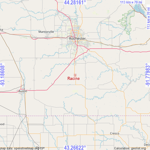
Racine GPS coordinates[2]
43° 46' 33.852" North, 92° 28' 58.62" West
| Map corner | latitude | longitude |
|---|---|---|
| Upper-left | 44.28161°, | -93.18608° |
| Center: | 43.77607°, | -92.48295° |
| Lower-right: | 43.26622°, | -91.77983° |
| Map W x H: | 112.9×112.9 km | = 70.2×70.2mi |
| max Lat: | 71.29058° ⇑12.5% North |
| Racine: | 43.77607° |
| min Lat: | ⇓87.5% South 19.06759° |
| min Long | Racine | max Long |
| -171.73463° | -92.48295° | -66.98998° |
| W 34.8%⇐ | ⇒65.2% E |
Elevation
Elevation of Racine is 392 m = 1286 ft, and this is 97.2 m = 319 ft above average elevation for this country.
| Max E: |
3189 m = 10463 ft | 16.9% |
| Racine | 392 m 1286 ft | |
| Avg. | 294.8 m = 967 ft | |
Min E: |
-60 m = -197 ft | 83.1% |
See also: United States elevation on elevation.city.
Geographical zone
Racine is located in North temperate zone (between Tropic of Cancer and the Arctic Circle). Distance of this Northern Tropic circle is 2261.5 km =1405.2 mi to South.| Distance of | km | miles | from Racine |
|---|---|---|---|
| North Pole | 5139.6 | 3193.6 | to North |
| Arctic Circle | 2533.7 | 1574.4 | to North |
| Tropic Cancer | 2261.5 | 1405.2 | to South |
| Equator | 4867.4 | 3024.5 | to South |


Nearby cities:
15 places around Racine: (largest is in red/bold)
• Adams
30.2 km =18.8 mi,  219°
219°
• Brownsdale
31.3 km =19.4 mi,  262°
262°
• Byron
31.4 km =19.5 mi,  335°
335°
• Chatfield
24.8 km =15.4 mi,  71°
71°
• Dover
35.2 km =21.9 mi,  51°
51°
• Eyota
31.2 km =19.4 mi,  40°
40°
• Grand Meadow
10.6 km =6.6 mi, 222°
• Hayfield
31.9 km =19.8 mi,  293°
293°
• Kasson
35.5 km =22.1 mi,  322°
322°
• Le Roy
29.7 km =18.5 mi,  183°
183°
• Mantorville
39.2 km =24.4 mi,  326°
326°
• Preston
34.2 km =21.3 mi,  110°
110°
• Rochester
27.3 km =17 mi,  2°
2°
• Spring Valley
12.5 km =7.8 mi,  142°
142°
• Stewartville
8.8 km =5.5 mi,  357°
357°
Sources, notices
• [Note1] Compared only with cities in United States existing in our database
• [Src1] Map data: © OpenStreetMap contributors (CC-BY-SA)
• [Src2] Other city data from geonames.org with taken over terms of usage.
• [Src3] Geographical zone / Annual Mean Temperature by Robert A. Rohde @ Wikipedia
