Rochester geodata
Rochester (Minnesota) is a seat of a second-order administrative division; located in United States in America/Chicago (GMT-5) time zone. With population of 112,225 people, there are 291 cities with bigger population in this country. Compared to other cities in United States, 88.5% of cities are located further ↓South; 65.2% of cities are located further →East and 75.1% of cities have lower elevation than Rochester. Note1


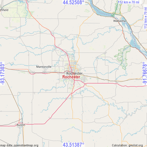
Rochester GPS coordinates[2]
44° 1' 17.868" North, 92° 28' 11.64" West
| Map corner | latitude | longitude |
|---|---|---|
| Upper-left | 44.52508°, | -93.17303° |
| Center: | 44.02163°, | -92.4699° |
| Lower-right: | 43.51387°, | -91.76678° |
| Map W x H: | 112.4×112.4 km | = 69.8×69.8mi |
| max Lat: | 71.29058° ⇑11.5% North |
| Rochester: | 44.02163° |
| min Lat: | ⇓88.5% South 19.06759° |
| min Long | Rochester | max Long |
| -171.73463° | -92.4699° | -66.98998° |
| W 34.8%⇐ | ⇒65.2% E |
Elevation
Elevation of Rochester is 314 m = 1030 ft, and this is 19.2 m = 63 ft above average elevation for this country.
| Max E: |
3189 m = 10463 ft | 24.9% |
| Rochester | 314 m 1030 ft | |
| Avg. | 294.8 m = 967 ft | |
Min E: |
-60 m = -197 ft | 75.1% |
See also: Rochester elevation on elevation.city.
Geographical zone
Rochester is located in North temperate zone (between Tropic of Cancer and the Arctic Circle). Distance of this Northern Tropic circle is 2288.8 km =1422.2 mi to South.| Distance of | km | miles | from Rochester |
|---|---|---|---|
| North Pole | 5112.3 | 3176.6 | to North |
| Arctic Circle | 2506.4 | 1557.4 | to North |
| Tropic Cancer | 2288.8 | 1422.2 | to South |
| Equator | 4894.7 | 3041.4 | to South |


Nearby cities:
15 places around Rochester: (largest is in red/bold)
• Byron
14.1 km =8.8 mi,  275°
275°
• Chatfield
29.8 km =18.5 mi,  131°
131°
• Dodge Center
30.8 km =19.1 mi,  271°
271°
• Dover
27 km =16.8 mi,  101°
101°
• Elgin
21.2 km =13.2 mi,  55°
55°
• Eyota
19.7 km =12.2 mi, 100°
• Kasson
22.5 km =14 mi, 272°
• Mantorville
23.4 km =14.5 mi, 283°
• Mazeppa
28.6 km =17.8 mi,  347°
347°
• Oronoco
16.9 km =10.5 mi,  342°
342°
• Pine Island
24.4 km =15.2 mi,  324°
324°
• Plainview
28.7 km =17.8 mi, 56°
• Racine
27.3 km =17 mi,  182°
182°
• Saint Charles
33 km =20.5 mi, 100°
• Stewartville
18.5 km =11.5 mi, 184°
Sources, notices
• [Note1] Compared only with cities in United States existing in our database
• [Src1] Map data: © OpenStreetMap contributors (CC-BY-SA)
• [Src2] Other city data from geonames.org with taken over terms of usage.
• [Src3] Geographical zone / Annual Mean Temperature by Robert A. Rohde @ Wikipedia
