Saint Paul geodata
Saint Paul (Minnesota) is a seat of a first-order administrative division; located in United States in America/Chicago (GMT-5) time zone. With population of 285,068 people, there are 76 cities with bigger population in this country. Compared to other cities in United States, 92.3% of cities are located further ↓South; 66.4% of cities are located further →East and 60.5% of cities have lower elevation than Saint Paul. Note1


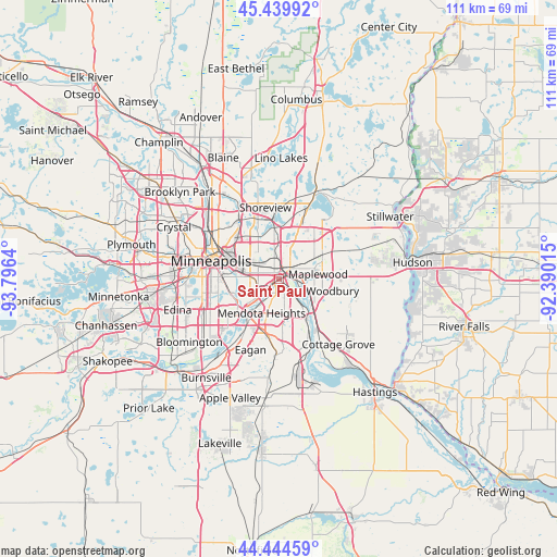
Saint Paul GPS coordinates[2]
44° 56' 39.876" North, 93° 5' 35.772" West
| Map corner | latitude | longitude |
|---|---|---|
| Upper-left | 45.43992°, | -93.7964° |
| Center: | 44.94441°, | -93.09327° |
| Lower-right: | 44.44459°, | -92.39015° |
| Map W x H: | 110.7×110.7 km | = 68.8×68.8mi |
| max Lat: | 71.29058° ⇑7.7% North |
| Saint Paul: | 44.94441° |
| min Lat: | ⇓92.3% South 19.06759° |
| min Long | Saint Paul | max Long |
| -171.73463° | -93.09327° | -66.98998° |
| W 33.6%⇐ | ⇒66.4% E |
Elevation
Elevation of Saint Paul is 242 m = 794 ft, and this is 52.8 m = 173 ft below average elevation for this country.
| Max E: |
3189 m = 10463 ft | 39.5% |
| Avg. | 294.8 m = 967 ft | |
| Saint Paul | 242 m = 794 ft | |
Min E: |
-60 m = -197 ft | 60.5% |
See also: Saint Paul elevation on elevation.city.
Geographical zone
Saint Paul is located in North temperate zone (between Tropic of Cancer and the Arctic Circle). Distance of this Northern Tropic circle is 2391.4 km =1485.9 mi to South.| Distance of | km | miles | from Saint Paul |
|---|---|---|---|
| North Pole | 5009.7 | 3112.9 | to North |
| Arctic Circle | 2403.8 | 1493.7 | to North |
| Tropic Cancer | 2391.4 | 1485.9 | to South |
| Equator | 4997.3 | 3105.2 | to South |


Nearby cities:
15 places around Saint Paul: (largest is in red/bold)
• Falcon Heights
7.8 km =4.8 mi,  312°
312°
• Landfall
9.2 km =5.7 mi,  85°
85°
• Lauderdale
10.7 km =6.6 mi,  304°
304°
• Lilydale
4.1 km =2.5 mi,  219°
219°
• Little Canada
9.2 km =5.7 mi,  2°
2°
• Maplewood
7.8 km =4.8 mi,  82°
82°
• Mendota Heights
7.6 km =4.7 mi,  207°
207°
• Newport
11.3 km =7 mi,  139°
139°
• North Saint Paul
11 km =6.8 mi,  46°
46°
• Oakdale
10.3 km =6.4 mi, 78°
• Roseville
8.5 km =5.3 mi,  323°
323°
• South Saint Paul
7.4 km =4.6 mi, 141°
• Sunfish Lake
8.2 km =5.1 mi,  182°
182°
• West Saint Paul
3.2 km =2 mi,  191°
191°
• Woodbury
10.8 km =6.7 mi,  102°
102°
Sources, notices
• [Note1] Compared only with cities in United States existing in our database
• [Src1] Map data: © OpenStreetMap contributors (CC-BY-SA)
• [Src2] Other city data from geonames.org with taken over terms of usage.
• [Src3] Geographical zone / Annual Mean Temperature by Robert A. Rohde @ Wikipedia
