Woodbury geodata
Woodbury (Minnesota) is a populated place; located in United States in America/Chicago (GMT-5) time zone. With population of 67,855 people, there are 616 cities with bigger population in this country. Compared to other cities in United States, 92.2% of cities are located further ↓South; 66.1% of cities are located further →East and 76.4% of cities have lower elevation than Woodbury. Note1


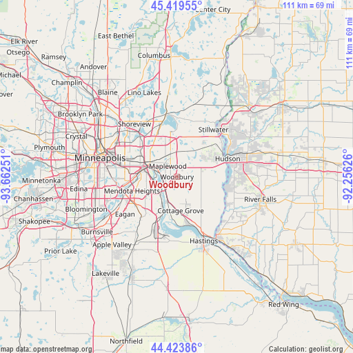
Woodbury GPS coordinates[2]
44° 55' 25.896" North, 92° 57' 33.768" West
| Map corner | latitude | longitude |
|---|---|---|
| Upper-left | 45.41955°, | -93.66251° |
| Center: | 44.92386°, | -92.95938° |
| Lower-right: | 44.42386°, | -92.25626° |
| Map W x H: | 110.7×110.7 km | = 68.8×68.8mi |
| max Lat: | 71.29058° ⇑7.8% North |
| Woodbury: | 44.92386° |
| min Lat: | ⇓92.2% South 19.06759° |
| min Long | Woodbury | max Long |
| -171.73463° | -92.95938° | -66.98998° |
| W 33.9%⇐ | ⇒66.1% E |
Elevation
Elevation of Woodbury is 323 m = 1060 ft, and this is 28.2 m = 93 ft above average elevation for this country.
| Max E: |
3189 m = 10463 ft | 23.6% |
| Woodbury | 323 m 1060 ft | |
| Avg. | 294.8 m = 967 ft | |
Min E: |
-60 m = -197 ft | 76.4% |
See also: Woodbury elevation on elevation.city.
Geographical zone
Woodbury is located in North temperate zone (between Tropic of Cancer and the Arctic Circle). Distance of this Northern Tropic circle is 2389.1 km =1484.5 mi to South.| Distance of | km | miles | from Woodbury |
|---|---|---|---|
| North Pole | 5012 | 3114.3 | to North |
| Arctic Circle | 2406.1 | 1495.1 | to North |
| Tropic Cancer | 2389.1 | 1484.5 | to South |
| Equator | 4995.1 | 3103.8 | to South |


Nearby cities:
15 places around Woodbury: (largest is in red/bold)
• Afton
14 km =8.7 mi,  99°
99°
• Cottage Grove
10.8 km =6.7 mi,  173°
173°
• Inver Grove Heights
10.7 km =6.6 mi,  217°
217°
• Lake Elmo
10.2 km =6.3 mi,  38°
38°
• Landfall
3.3 km =2.1 mi,  335°
335°
• Lilydale
13.2 km =8.2 mi,  266°
266°
• Maplewood
4.3 km =2.7 mi,  318°
318°
• Newport
7.2 km =4.5 mi,  206°
206°
• North Saint Paul
10.2 km =6.3 mi,  345°
345°
• Oakdale
4.4 km =2.7 mi, 354°
• Saint Paul
10.8 km =6.7 mi,  282°
282°
• Saint Paul Park
9.4 km =5.8 mi,  195°
195°
• South Saint Paul
6.9 km =4.3 mi,  239°
239°
• Sunfish Lake
12.4 km =7.7 mi, 241°
• West Saint Paul
11.2 km =7 mi, 265°
Sources, notices
• [Note1] Compared only with cities in United States existing in our database
• [Src1] Map data: © OpenStreetMap contributors (CC-BY-SA)
• [Src2] Other city data from geonames.org with taken over terms of usage.
• [Src3] Geographical zone / Annual Mean Temperature by Robert A. Rohde @ Wikipedia
