Maplewood geodata
Maplewood (Minnesota) is a populated place; located in United States in America/Chicago (GMT-5) time zone. With population of 40,567 people, there are 1191 cities with bigger population in this country. Compared to other cities in United States, 92.4% of cities are located further ↓South; 66.2% of cities are located further →East and 72.8% of cities have lower elevation than Maplewood. Note1


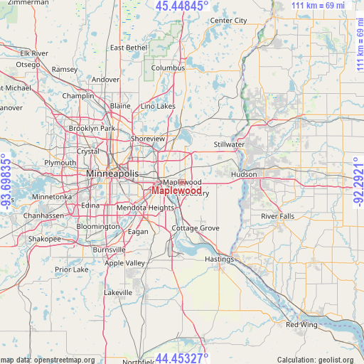
Maplewood GPS coordinates[2]
44° 57' 10.872" North, 92° 59' 42.792" West
| Map corner | latitude | longitude |
|---|---|---|
| Upper-left | 45.44845°, | -93.69835° |
| Center: | 44.95302°, | -92.99522° |
| Lower-right: | 44.45327°, | -92.2921° |
| Map W x H: | 110.7×110.7 km | = 68.8×68.8mi |
| max Lat: | 71.29058° ⇑7.6% North |
| Maplewood: | 44.95302° |
| min Lat: | ⇓92.4% South 19.06759° |
| min Long | Maplewood | max Long |
| -171.73463° | -92.99522° | -66.98998° |
| W 33.8%⇐ | ⇒66.2% E |
Elevation
Elevation of Maplewood is 300 m = 984 ft, and this is 5.2 m = 17 ft above average elevation for this country.
| Max E: |
3189 m = 10463 ft | 27.2% |
| Maplewood | 300 m 984 ft | |
| Avg. | 294.8 m = 967 ft | |
Min E: |
-60 m = -197 ft | 72.8% |
See also: Maplewood elevation on elevation.city.
Geographical zone
Maplewood is located in North temperate zone (between Tropic of Cancer and the Arctic Circle). Distance of this Northern Tropic circle is 2392.4 km =1486.6 mi to South.| Distance of | km | miles | from Maplewood |
|---|---|---|---|
| North Pole | 5008.8 | 3112.3 | to North |
| Arctic Circle | 2402.9 | 1493.1 | to North |
| Tropic Cancer | 2392.4 | 1486.6 | to South |
| Equator | 4998.3 | 3105.8 | to South |


Nearby cities:
15 places around Maplewood: (largest is in red/bold)
• Birchwood
12.1 km =7.5 mi,  7°
7°
• Inver Grove Heights
12.3 km =7.6 mi,  197°
197°
• Lake Elmo
10.3 km =6.4 mi,  62°
62°
• Landfall
1.5 km =0.9 mi,  99°
99°
• Lilydale
11.1 km =6.9 mi,  248°
248°
• Little Canada
11 km =6.8 mi,  318°
318°
• Newport
9.6 km =6 mi,  182°
182°
• North Saint Paul
6.6 km =4.1 mi,  2°
2°
• Oakdale
2.6 km =1.6 mi, 64°
• Saint Paul
7.8 km =4.8 mi,  262°
262°
• Saint Paul Park
12.3 km =7.6 mi, 178°
• South Saint Paul
7.4 km =4.6 mi,  205°
205°
• Sunfish Lake
12.2 km =7.6 mi,  221°
221°
• West Saint Paul
9.3 km =5.8 mi,  243°
243°
• Woodbury
4.3 km =2.7 mi,  138°
138°
Sources, notices
• [Note1] Compared only with cities in United States existing in our database
• [Src1] Map data: © OpenStreetMap contributors (CC-BY-SA)
• [Src2] Other city data from geonames.org with taken over terms of usage.
• [Src3] Geographical zone / Annual Mean Temperature by Robert A. Rohde @ Wikipedia
