Spicer geodata
Spicer (Minnesota) is a populated place; located in United States in America/Chicago (GMT-5) time zone. With population of 1,196 people, there are 15147 cities with bigger population in this country. Compared to other cities in United States, 93.3% of cities are located further ↓South; 70.9% of cities are located further →East and 80.4% of cities have lower elevation than Spicer. Note1


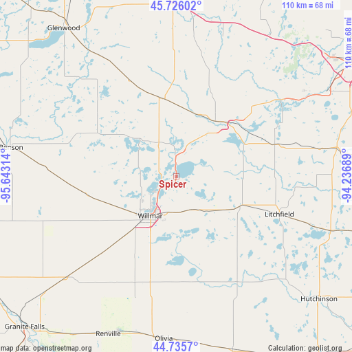
Spicer GPS coordinates[2]
45° 13' 58.872" North, 94° 56' 24.036" West
| Map corner | latitude | longitude |
|---|---|---|
| Upper-left | 45.72602°, | -95.64314° |
| Center: | 45.23302°, | -94.94001° |
| Lower-right: | 44.7357°, | -94.23689° |
| Map W x H: | 110.1×110.1 km | = 68.4×68.4mi |
| max Lat: | 71.29058° ⇑6.7% North |
| Spicer: | 45.23302° |
| min Lat: | ⇓93.3% South 19.06759° |
| min Long | Spicer | max Long |
| -171.73463° | -94.94001° | -66.98998° |
| W 29.1%⇐ | ⇒70.9% E |
Elevation
Elevation of Spicer is 357 m = 1171 ft, and this is 62.2 m = 204 ft above average elevation for this country.
| Max E: |
3189 m = 10463 ft | 19.6% |
| Spicer | 357 m 1171 ft | |
| Avg. | 294.8 m = 967 ft | |
Min E: |
-60 m = -197 ft | 80.4% |
See also: United States elevation on elevation.city.
Geographical zone
Spicer is located in North temperate zone (between Tropic of Cancer and the Arctic Circle). Distance of this North polar circle is 2371.7 km =1473.7 mi to North.| Distance of | km | miles | from Spicer |
|---|---|---|---|
| North Pole | 4977.6 | 3092.9 | to North |
| Arctic Circle | 2371.7 | 1473.7 | to North |
| Tropic Cancer | 2423.5 | 1505.9 | to South |
| Equator | 5029.4 | 3125.1 | to South |


Nearby cities:
15 places around Spicer: (largest is in red/bold)
• Atwater
16.5 km =10.3 mi,  129°
129°
• Belgrade
25 km =15.5 mi,  348°
348°
• Brooten
33.1 km =20.6 mi,  334°
334°
• Clara City
45.6 km =28.3 mi,  227°
227°
• Eden Valley
32.5 km =20.2 mi,  71°
71°
• Grove City
22.1 km =13.7 mi,  114°
114°
• Kerkhoven
30.1 km =18.7 mi,  261°
261°
• Litchfield
34.4 km =21.4 mi, 110°
• New London
7.6 km =4.7 mi,  357°
357°
• Paynesville
24.2 km =15 mi,  47°
47°
• Pennock
20.8 km =12.9 mi,  243°
243°
• Raymond
33.6 km =20.9 mi,  224°
224°
• Richmond
41.1 km =25.5 mi, 53°
• Watkins
42.6 km =26.5 mi,  77°
77°
• Willmar
14.8 km =9.2 mi,  213°
213°
Sources, notices
• [Note1] Compared only with cities in United States existing in our database
• [Src1] Map data: © OpenStreetMap contributors (CC-BY-SA)
• [Src2] Other city data from geonames.org with taken over terms of usage.
• [Src3] Geographical zone / Annual Mean Temperature by Robert A. Rohde @ Wikipedia
