Brooten geodata
Brooten (Minnesota) is a populated place; located in United States in America/Chicago (GMT-6) time zone. With population of 745 people, there are 18255 cities with bigger population in this country. Compared to other cities in United States, 94% of cities are located further ↓South; 71.4% of cities are located further →East and 83.7% of cities have lower elevation than Brooten. Note1


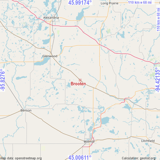
Brooten GPS coordinates[2]
45° 30' 3.888" North, 95° 7' 28.092" West
| Map corner | latitude | longitude |
|---|---|---|
| Upper-left | 45.99174°, | -95.8276° |
| Center: | 45.50108°, | -95.12447° |
| Lower-right: | 45.00611°, | -94.42135° |
| Map W x H: | 109.6×109.6 km | = 68.1×68.1mi |
| max Lat: | 71.29058° ⇑6% North |
| Brooten: | 45.50108° |
| min Lat: | ⇓94% South 19.06759° |
| min Long | Brooten | max Long |
| -171.73463° | -95.12447° | -66.98998° |
| W 28.6%⇐ | ⇒71.4% E |
Elevation
Elevation of Brooten is 400 m = 1312 ft, and this is 105.2 m = 345 ft above average elevation for this country.
| Max E: |
3189 m = 10463 ft | 16.3% |
| Brooten | 400 m 1312 ft | |
| Avg. | 294.8 m = 967 ft | |
Min E: |
-60 m = -197 ft | 83.7% |
See also: United States elevation on elevation.city.
Geographical zone
Brooten is located in North temperate zone (between Tropic of Cancer and the Arctic Circle). Distance of this North polar circle is 2341.9 km =1455.2 mi to North.| Distance of | km | miles | from Brooten |
|---|---|---|---|
| North Pole | 4947.8 | 3074.4 | to North |
| Arctic Circle | 2341.9 | 1455.2 | to North |
| Tropic Cancer | 2453.3 | 1524.4 | to South |
| Equator | 5059.2 | 3143.6 | to South |


Nearby cities:
15 places around Brooten: (largest is in red/bold)
• Albany
45.5 km =28.3 mi,  71°
71°
• Belgrade
10.8 km =6.7 mi,  119°
119°
• Benson
42.5 km =26.4 mi,  240°
240°
• Freeport
38.3 km =23.8 mi,  62°
62°
• Glenwood
26.5 km =16.5 mi,  308°
308°
• Kerkhoven
37.5 km =23.3 mi,  204°
204°
• Melrose
31.3 km =19.4 mi,  51°
51°
• New London
26.3 km =16.3 mi,  147°
147°
• Osakis
40.7 km =25.3 mi,  356°
356°
• Paynesville
34.9 km =21.7 mi,  112°
112°
• Pennock
39.4 km =24.5 mi,  185°
185°
• Sauk Centre
29.5 km =18.3 mi,  26°
26°
• Spicer
33.1 km =20.6 mi, 154°
• Starbuck
34.1 km =21.2 mi,  291°
291°
• Willmar
42.6 km =26.5 mi,  171°
171°
Sources, notices
• [Note1] Compared only with cities in United States existing in our database
• [Src1] Map data: © OpenStreetMap contributors (CC-BY-SA)
• [Src2] Other city data from geonames.org with taken over terms of usage.
• [Src3] Geographical zone / Annual Mean Temperature by Robert A. Rohde @ Wikipedia
