Trenton geodata
Trenton (Missouri) is a seat of a second-order administrative division; located in United States in America/Chicago (GMT-5) time zone. With population of 5,896 people, there are 6474 cities with bigger population in this country. Compared to other cities in United States, 54.3% of cities are located further ↓South; 67.8% of cities are located further →East and 64.8% of cities have lower elevation than Trenton. Note1


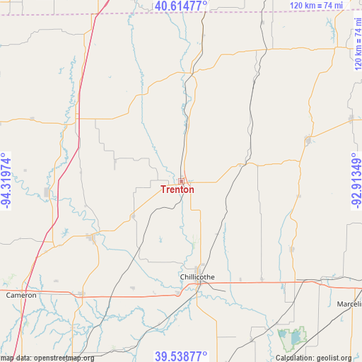
Trenton GPS coordinates[2]
40° 4' 44.04" North, 93° 36' 59.796" West
| Map corner | latitude | longitude |
|---|---|---|
| Upper-left | 40.61477°, | -94.31974° |
| Center: | 40.0789°, | -93.61661° |
| Lower-right: | 39.53877°, | -92.91349° |
| Map W x H: | 119.6×119.6 km | = 74.3×74.3mi |
| max Lat: | 71.29058° ⇑45.7% North |
| Trenton: | 40.0789° |
| min Lat: | ⇓54.3% South 19.06759° |
| min Long | Trenton | max Long |
| -171.73463° | -93.61661° | -66.98998° |
| W 32.2%⇐ | ⇒67.8% E |
Elevation
Elevation of Trenton is 261 m = 856 ft, and this is 33.8 m = 111 ft below average elevation for this country.
| Max E: |
3189 m = 10463 ft | 35.2% |
| Avg. | 294.8 m = 967 ft | |
| Trenton | 261 m = 856 ft | |
Min E: |
-60 m = -197 ft | 64.8% |
See also: United States elevation on elevation.city.
Geographical zone
Trenton is located in North temperate zone (between Tropic of Cancer and the Arctic Circle). Distance of this Northern Tropic circle is 1850.4 km =1149.8 mi to South.| Distance of | km | miles | from Trenton |
|---|---|---|---|
| North Pole | 5550.7 | 3449 | to North |
| Arctic Circle | 2944.8 | 1829.8 | to North |
| Tropic Cancer | 1850.4 | 1149.8 | to South |
| Equator | 4456.4 | 2769.1 | to South |


Nearby cities:
15 places around Trenton: (largest is in red/bold)
• Albany
63.6 km =39.5 mi,  287°
287°
• Bethany
40.8 km =25.4 mi,  301°
301°
• Braymer
56.8 km =35.3 mi,  195°
195°
• Brookfield
56.7 km =35.2 mi,  125°
125°
• Cameron
65.2 km =40.5 mi,  234°
234°
• Chillicothe
32 km =19.9 mi,  170°
170°
• Gallatin
34.7 km =21.6 mi,  238°
238°
• Green City
60.2 km =37.4 mi,  69°
69°
• Hamilton
49.5 km =30.8 mi,  221°
221°
• Jamesport
19.5 km =12.1 mi, 233°
• Kingston
60.3 km =37.5 mi, 216°
• Linneus
42.7 km =26.5 mi,  121°
121°
• Milan
44 km =27.3 mi, 71°
• Princeton
35.9 km =22.3 mi,  4°
4°
• Terre Haute
51.6 km =32.1 mi,  38°
38°
Sources, notices
• [Note1] Compared only with cities in United States existing in our database
• [Src1] Map data: © OpenStreetMap contributors (CC-BY-SA)
• [Src2] Other city data from geonames.org with taken over terms of usage.
• [Src3] Geographical zone / Annual Mean Temperature by Robert A. Rohde @ Wikipedia
