Terre Haute geodata
Terre Haute (Missouri) is a populated place; located in United States in America/Chicago (GMT-5) time zone. With population of 2,320 people, there are 11044 cities with bigger population in this country. Compared to other cities in United States, 58.3% of cities are located further ↓South; 66.8% of cities are located further →East and 75.7% of cities have lower elevation than Terre Haute. Note1


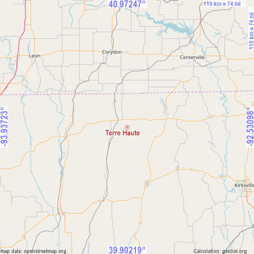
Terre Haute GPS coordinates[2]
40° 26' 22.056" North, 93° 14' 2.76" West
| Map corner | latitude | longitude |
|---|---|---|
| Upper-left | 40.97247°, | -93.93723° |
| Center: | 40.43946°, | -93.2341° |
| Lower-right: | 39.90219°, | -92.53098° |
| Map W x H: | 119×119 km | = 73.9×73.9mi |
| max Lat: | 71.29058° ⇑41.7% North |
| Terre Haute: | 40.43946° |
| min Lat: | ⇓58.3% South 19.06759° |
| min Long | Terre Haute | max Long |
| -171.73463° | -93.2341° | -66.98998° |
| W 33.2%⇐ | ⇒66.8% E |
Elevation
Elevation of Terre Haute is 318 m = 1043 ft, and this is 23.2 m = 76 ft above average elevation for this country.
| Max E: |
3189 m = 10463 ft | 24.3% |
| Terre Haute | 318 m 1043 ft | |
| Avg. | 294.8 m = 967 ft | |
Min E: |
-60 m = -197 ft | 75.7% |
See also: United States elevation on elevation.city.
Geographical zone
Terre Haute is located in North temperate zone (between Tropic of Cancer and the Arctic Circle). Distance of this Northern Tropic circle is 1890.5 km =1174.7 mi to South.| Distance of | km | miles | from Terre Haute |
|---|---|---|---|
| North Pole | 5510.6 | 3424.1 | to North |
| Arctic Circle | 2904.7 | 1804.9 | to North |
| Tropic Cancer | 1890.5 | 1174.7 | to South |
| Equator | 4496.4 | 2793.9 | to South |


Nearby cities:
15 places around Terre Haute: (largest is in red/bold)
• Centerville
44.7 km =27.8 mi,  42°
42°
• Corydon
36 km =22.4 mi,  348°
348°
• Green City
30.4 km =18.9 mi,  128°
128°
• Kirksville
61.5 km =38.2 mi,  116°
116°
• Lancaster
60.4 km =37.5 mi,  81°
81°
• Leon
54.7 km =34 mi,  307°
307°
• Milan
27.9 km =17.3 mi,  160°
160°
• Moravia
61.4 km =38.2 mi, 35°
• Moulton
54.4 km =33.8 mi,  59°
59°
• Princeton
29.6 km =18.4 mi,  261°
261°
• Queen City
56.5 km =35.1 mi,  93°
93°
• Russell
60.4 km =37.5 mi,  2°
2°
• Seymour
28.7 km =17.8 mi,  19°
19°
• Trenton
51.6 km =32.1 mi,  218°
218°
• Unionville
20 km =12.4 mi, 77°
Sources, notices
• [Note1] Compared only with cities in United States existing in our database
• [Src1] Map data: © OpenStreetMap contributors (CC-BY-SA)
• [Src2] Other city data from geonames.org with taken over terms of usage.
• [Src3] Geographical zone / Annual Mean Temperature by Robert A. Rohde @ Wikipedia
