Ashley geodata
Ashley (North Dakota) is a seat of a second-order administrative division; located in United States in America/Chicago (GMT-5) time zone. With population of 726 people, there are 18438 cities with bigger population in this country. Compared to other cities in United States, 95.1% of cities are located further ↓South; 80.3% of cities are located further →East and 89.9% of cities have lower elevation than Ashley. Note1


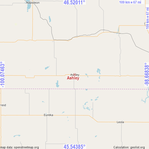
Ashley GPS coordinates[2]
46° 2' 2.904" North, 99° 22' 17.4" West
| Map corner | latitude | longitude |
|---|---|---|
| Upper-left | 46.52011°, | -100.07463° |
| Center: | 46.03414°, | -99.3715° |
| Lower-right: | 45.54385°, | -98.66838° |
| Map W x H: | 108.5×108.5 km | = 67.4×67.4mi |
| max Lat: | 71.29058° ⇑4.9% North |
| Ashley: | 46.03414° |
| min Lat: | ⇓95.1% South 19.06759° |
| min Long | Ashley | max Long |
| -171.73463° | -99.3715° | -66.98998° |
| W 19.7%⇐ | ⇒80.3% E |
Elevation
Elevation of Ashley is 614 m = 2014 ft, and this is 319.2 m = 1047 ft above average elevation for this country.
| Max E: |
3189 m = 10463 ft | 10.1% |
| Ashley | 614 m 2014 ft | |
| Avg. | 294.8 m = 967 ft | |
Min E: |
-60 m = -197 ft | 89.9% |
See also: United States elevation on elevation.city.
Geographical zone
Ashley is located in North temperate zone (between Tropic of Cancer and the Arctic Circle). Distance of this North polar circle is 2282.7 km =1418.4 mi to North.| Distance of | km | miles | from Ashley |
|---|---|---|---|
| North Pole | 4888.5 | 3037.6 | to North |
| Arctic Circle | 2282.7 | 1418.4 | to North |
| Tropic Cancer | 2512.6 | 1561.3 | to South |
| Equator | 5118.5 | 3180.5 | to South |


Nearby cities:
15 places around Ashley: (largest is in red/bold)
• Aberdeen
93.4 km =58 mi,  132°
132°
• Bowdle
68.2 km =42.4 mi,  198°
198°
• Edgeley
62.1 km =38.6 mi,  54°
54°
• Ellendale
65.3 km =40.6 mi,  93°
93°
• Eureka
35.1 km =21.8 mi,  213°
213°
• Fort Yates
97.3 km =60.5 mi,  273°
273°
• Ipswich
70.7 km =43.9 mi,  157°
157°
• LaMoure
90.3 km =56.1 mi,  66°
66°
• Leola
48.1 km =29.9 mi,  136°
136°
• Linton
71.2 km =44.2 mi,  291°
291°
• Mobridge
98.8 km =61.4 mi,  235°
235°
• Mound City
64 km =39.8 mi, 237°
• Napoleon
61 km =37.9 mi,  329°
329°
• Selby
77.9 km =48.4 mi,  221°
221°
• Wishek
28.6 km =17.8 mi, 330°
Sources, notices
• [Note1] Compared only with cities in United States existing in our database
• [Src1] Map data: © OpenStreetMap contributors (CC-BY-SA)
• [Src2] Other city data from geonames.org with taken over terms of usage.
• [Src3] Geographical zone / Annual Mean Temperature by Robert A. Rohde @ Wikipedia
