Fort Calhoun geodata
Fort Calhoun (Nebraska) is a populated place; located in United States in America/Chicago (GMT-5) time zone. With population of 917 people, there are 16884 cities with bigger population in this country. Compared to other cities in United States, 70.4% of cities are located further ↓South; 73.5% of cities are located further →East and 78.2% of cities have lower elevation than Fort Calhoun. Note1


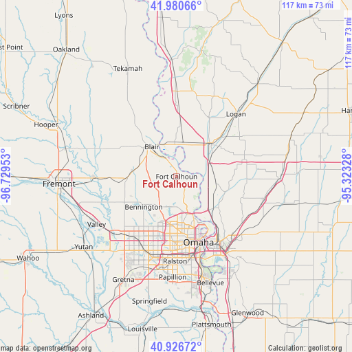
Fort Calhoun GPS coordinates[2]
41° 27' 20.988" North, 96° 1' 35.04" West
| Map corner | latitude | longitude |
|---|---|---|
| Upper-left | 41.98066°, | -96.72953° |
| Center: | 41.45583°, | -96.0264° |
| Lower-right: | 40.92672°, | -95.32328° |
| Map W x H: | 117.2×117.2 km | = 72.8×72.8mi |
| max Lat: | 71.29058° ⇑29.6% North |
| Fort Calhoun: | 41.45583° |
| min Lat: | ⇓70.4% South 19.06759° |
| min Long | Fort Calhoun | max Long |
| -171.73463° | -96.0264° | -66.98998° |
| W 26.5%⇐ | ⇒73.5% E |
Elevation
Elevation of Fort Calhoun is 337 m = 1106 ft, and this is 42.2 m = 138 ft above average elevation for this country.
| Max E: |
3189 m = 10463 ft | 21.8% |
| Fort Calhoun | 337 m 1106 ft | |
| Avg. | 294.8 m = 967 ft | |
Min E: |
-60 m = -197 ft | 78.2% |
See also: United States elevation on elevation.city.
Geographical zone
Fort Calhoun is located in North temperate zone (between Tropic of Cancer and the Arctic Circle). Distance of this Northern Tropic circle is 2003.5 km =1244.9 mi to South.| Distance of | km | miles | from Fort Calhoun |
|---|---|---|---|
| North Pole | 5397.6 | 3353.9 | to North |
| Arctic Circle | 2791.7 | 1734.7 | to North |
| Tropic Cancer | 2003.5 | 1244.9 | to South |
| Equator | 4609.5 | 2864.2 | to South |


Nearby cities:
15 places around Fort Calhoun: (largest is in red/bold)
• Arlington
27.1 km =16.8 mi,  269°
269°
• Bennington
14.9 km =9.3 mi,  227°
227°
• Blair
12.8 km =8 mi,  320°
320°
• Boys Town
23.4 km =14.5 mi,  202°
202°
• Carter Lake
20.5 km =12.7 mi,  153°
153°
• Council Bluffs
25.6 km =15.9 mi, 147°
• Crescent
17.3 km =10.7 mi,  125°
125°
• Elkhorn
25.6 km =15.9 mi,  222°
222°
• La Vista
30.2 km =18.8 mi,  180°
180°
• Logan
28.7 km =17.8 mi,  43°
43°
• Missouri Valley
16.1 km =10 mi,  45°
45°
• Omaha
23.3 km =14.5 mi,  162°
162°
• Ralston
27.9 km =17.3 mi, 182°
• Underwood
30.1 km =18.7 mi,  104°
104°
• Waterloo
28.6 km =17.8 mi, 229°
Sources, notices
• [Note1] Compared only with cities in United States existing in our database
• [Src1] Map data: © OpenStreetMap contributors (CC-BY-SA)
• [Src2] Other city data from geonames.org with taken over terms of usage.
• [Src3] Geographical zone / Annual Mean Temperature by Robert A. Rohde @ Wikipedia
