Omaha geodata
Omaha (Nebraska) is a seat of a second-order administrative division; located in United States in America/Chicago (GMT-5) time zone. With population of 443,885 people, there are 48 cities with bigger population in this country. Compared to other cities in United States, 68.4% of cities are located further ↓South; 73.3% of cities are located further →East and 75.3% of cities have lower elevation than Omaha. Note1


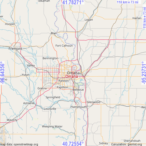
Omaha GPS coordinates[2]
41° 15' 22.536" North, 95° 56' 25.548" West
| Map corner | latitude | longitude |
|---|---|---|
| Upper-left | 41.78271°, | -96.64356° |
| Center: | 41.25626°, | -95.94043° |
| Lower-right: | 40.72554°, | -95.23731° |
| Map W x H: | 117.5×117.5 km | = 73×73mi |
| max Lat: | 71.29058° ⇑31.6% North |
| Omaha: | 41.25626° |
| min Lat: | ⇓68.4% South 19.06759° |
| min Long | Omaha | max Long |
| -171.73463° | -95.94043° | -66.98998° |
| W 26.7%⇐ | ⇒73.3% E |
Elevation
Elevation of Omaha is 315 m = 1033 ft, and this is 20.2 m = 66 ft above average elevation for this country.
| Max E: |
3189 m = 10463 ft | 24.7% |
| Omaha | 315 m 1033 ft | |
| Avg. | 294.8 m = 967 ft | |
Min E: |
-60 m = -197 ft | 75.3% |
See also: Omaha elevation on elevation.city.
Geographical zone
Omaha is located in North temperate zone (between Tropic of Cancer and the Arctic Circle). Distance of this Northern Tropic circle is 1981.3 km =1231.1 mi to South.| Distance of | km | miles | from Omaha |
|---|---|---|---|
| North Pole | 5419.8 | 3367.7 | to North |
| Arctic Circle | 2813.9 | 1748.5 | to North |
| Tropic Cancer | 1981.3 | 1231.1 | to South |
| Equator | 4587.3 | 2850.4 | to South |


Nearby cities:
15 places around Omaha: (largest is in red/bold)
• Bellevue
13.9 km =8.6 mi,  162°
162°
• Bennington
21.8 km =13.5 mi,  303°
303°
• Boys Town
16 km =9.9 mi,  271°
271°
• Carter Lake
4.2 km =2.6 mi,  26°
26°
• Chalco
19.3 km =12 mi,  245°
245°
• Council Bluffs
6.7 km =4.2 mi,  84°
84°
• Crescent
13.9 km =8.6 mi, 29°
• Elkhorn
24.8 km =15.4 mi,  277°
277°
• Fort Calhoun
23.3 km =14.5 mi,  342°
342°
• La Vista
11.1 km =6.9 mi,  223°
223°
• Offutt Air Force Base
15.2 km =9.4 mi,  173°
173°
• Papillion
14.2 km =8.8 mi, 216°
• Ralston
10.2 km =6.3 mi,  236°
236°
• Springfield
25.3 km =15.7 mi, 219°
• Underwood
26.4 km =16.4 mi,  56°
56°
Sources, notices
• [Note1] Compared only with cities in United States existing in our database
• [Src1] Map data: © OpenStreetMap contributors (CC-BY-SA)
• [Src2] Other city data from geonames.org with taken over terms of usage.
• [Src3] Geographical zone / Annual Mean Temperature by Robert A. Rohde @ Wikipedia
