Holdrege geodata
Holdrege (Nebraska) is a seat of a second-order administrative division; located in United States in America/Chicago (GMT-5) time zone. With population of 5,561 people, there are 6712 cities with bigger population in this country. Compared to other cities in United States, 58.4% of cities are located further ↓South; 80.3% of cities are located further →East and 91.1% of cities have lower elevation than Holdrege. Note1


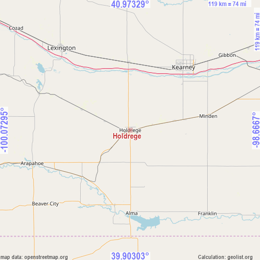
Holdrege GPS coordinates[2]
40° 26' 25.044" North, 99° 22' 11.352" West
| Map corner | latitude | longitude |
|---|---|---|
| Upper-left | 40.97329°, | -100.07295° |
| Center: | 40.44029°, | -99.36982° |
| Lower-right: | 39.90303°, | -98.6667° |
| Map W x H: | 119×119 km | = 73.9×73.9mi |
| max Lat: | 71.29058° ⇑41.6% North |
| Holdrege: | 40.44029° |
| min Lat: | ⇓58.4% South 19.06759° |
| min Long | Holdrege | max Long |
| -171.73463° | -99.36982° | -66.98998° |
| W 19.7%⇐ | ⇒80.3% E |
Elevation
Elevation of Holdrege is 716 m = 2349 ft, and this is 421.2 m = 1382 ft above average elevation for this country.
| Max E: |
3189 m = 10463 ft | 8.9% |
| Holdrege | 716 m 2349 ft | |
| Avg. | 294.8 m = 967 ft | |
Min E: |
-60 m = -197 ft | 91.1% |
See also: United States elevation on elevation.city.
Geographical zone
Holdrege is located in North temperate zone (between Tropic of Cancer and the Arctic Circle). Distance of this Northern Tropic circle is 1890.6 km =1174.8 mi to South.| Distance of | km | miles | from Holdrege |
|---|---|---|---|
| North Pole | 5510.5 | 3424.1 | to North |
| Arctic Circle | 2904.6 | 1804.8 | to North |
| Tropic Cancer | 1890.6 | 1174.8 | to South |
| Equator | 4496.5 | 2794 | to South |


Nearby cities:
15 places around Holdrege: (largest is in red/bold)
• Alma
38.1 km =23.7 mi,  179°
179°
• Arapahoe
47.4 km =29.5 mi,  251°
251°
• Axtell
21 km =13 mi,  78°
78°
• Beaver City
51.5 km =32 mi,  229°
229°
• Bertrand
24.3 km =15.1 mi,  293°
293°
• Elm Creek
31 km =19.3 mi,  359°
359°
• Elwood
44.7 km =27.8 mi, 291°
• Franklin
52.1 km =32.4 mi,  137°
137°
• Gibbon
56 km =34.8 mi,  52°
52°
• Kearney
37.7 km =23.4 mi,  40°
40°
• Kenesaw
63.5 km =39.5 mi,  71°
71°
• Lexington
49.2 km =30.6 mi,  320°
320°
• Minden
36.3 km =22.6 mi, 79°
• Overton
36.1 km =22.4 mi,  336°
336°
• Oxford
30.9 km =19.2 mi, 226°
Sources, notices
• [Note1] Compared only with cities in United States existing in our database
• [Src1] Map data: © OpenStreetMap contributors (CC-BY-SA)
• [Src2] Other city data from geonames.org with taken over terms of usage.
• [Src3] Geographical zone / Annual Mean Temperature by Robert A. Rohde @ Wikipedia
