Gibbon geodata
Gibbon (Nebraska) is a populated place; located in United States in America/Chicago (GMT-5) time zone. With population of 1,879 people, there are 12278 cities with bigger population in this country. Compared to other cities in United States, 62.3% of cities are located further ↓South; 79.8% of cities are located further →East and 90.1% of cities have lower elevation than Gibbon. Note1


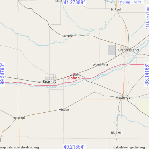
Gibbon GPS coordinates[2]
40° 44' 54.06" North, 98° 50' 41.28" West
| Map corner | latitude | longitude |
|---|---|---|
| Upper-left | 41.27889°, | -99.54793° |
| Center: | 40.74835°, | -98.8448° |
| Lower-right: | 40.21354°, | -98.14168° |
| Map W x H: | 118.5×118.5 km | = 73.6×73.6mi |
| max Lat: | 71.29058° ⇑37.7% North |
| Gibbon: | 40.74835° |
| min Lat: | ⇓62.3% South 19.06759° |
| min Long | Gibbon | max Long |
| -171.73463° | -98.8448° | -66.98998° |
| W 20.2%⇐ | ⇒79.8% E |
Elevation
Elevation of Gibbon is 631 m = 2070 ft, and this is 336.2 m = 1103 ft above average elevation for this country.
| Max E: |
3189 m = 10463 ft | 9.9% |
| Gibbon | 631 m 2070 ft | |
| Avg. | 294.8 m = 967 ft | |
Min E: |
-60 m = -197 ft | 90.1% |
See also: United States elevation on elevation.city.
Geographical zone
Gibbon is located in North temperate zone (between Tropic of Cancer and the Arctic Circle). Distance of this Northern Tropic circle is 1924.9 km =1196.1 mi to South.| Distance of | km | miles | from Gibbon |
|---|---|---|---|
| North Pole | 5476.3 | 3402.8 | to North |
| Arctic Circle | 2870.4 | 1783.6 | to North |
| Tropic Cancer | 1924.9 | 1196.1 | to South |
| Equator | 4530.8 | 2815.3 | to South |


Nearby cities:
15 places around Gibbon: (largest is in red/bold)
• Alda
34.5 km =21.4 mi,  66°
66°
• Axtell
38.3 km =23.8 mi,  218°
218°
• Cairo
34.5 km =21.4 mi,  35°
35°
• Doniphan
40.1 km =24.9 mi,  86°
86°
• Elm Creek
44.5 km =27.7 mi,  265°
265°
• Grand Island
46.6 km =29 mi, 65°
• Hastings
42.5 km =26.4 mi,  115°
115°
• Holdrege
56 km =34.8 mi,  232°
232°
• Juniata
33.5 km =20.8 mi, 121°
• Kearney
20.7 km =12.9 mi,  254°
254°
• Kenesaw
21.2 km =13.2 mi,  131°
131°
• Minden
29.1 km =18.1 mi,  197°
197°
• Ravenna
31.4 km =19.5 mi,  349°
349°
• Shelton
10.2 km =6.3 mi, 70°
• Wood River
22.1 km =13.7 mi, 68°
Sources, notices
• [Note1] Compared only with cities in United States existing in our database
• [Src1] Map data: © OpenStreetMap contributors (CC-BY-SA)
• [Src2] Other city data from geonames.org with taken over terms of usage.
• [Src3] Geographical zone / Annual Mean Temperature by Robert A. Rohde @ Wikipedia
