Minden geodata
Minden (Nebraska) is a seat of a second-order administrative division; located in United States in America/Chicago (GMT-5) time zone. With population of 3,006 people, there are 9623 cities with bigger population in this country. Compared to other cities in United States, 58.9% of cities are located further ↓South; 79.9% of cities are located further →East and 90.6% of cities have lower elevation than Minden. Note1


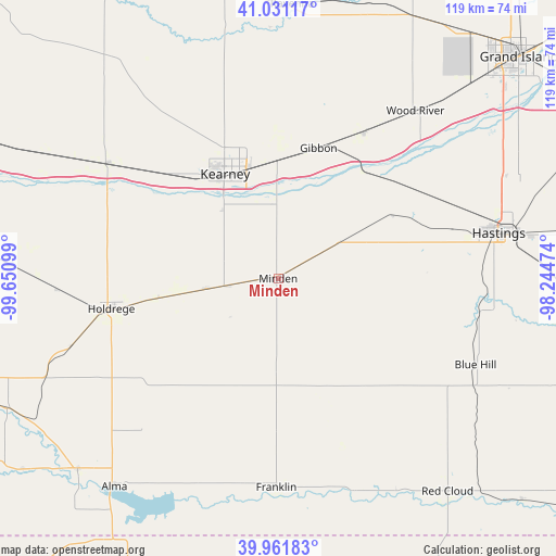
Minden GPS coordinates[2]
40° 29' 55.068" North, 98° 56' 52.296" West
| Map corner | latitude | longitude |
|---|---|---|
| Upper-left | 41.03117°, | -99.65099° |
| Center: | 40.49863°, | -98.94786° |
| Lower-right: | 39.96183°, | -98.24474° |
| Map W x H: | 118.9×118.9 km | = 73.9×73.9mi |
| max Lat: | 71.29058° ⇑41.1% North |
| Minden: | 40.49863° |
| min Lat: | ⇓58.9% South 19.06759° |
| min Long | Minden | max Long |
| -171.73463° | -98.94786° | -66.98998° |
| W 20.1%⇐ | ⇒79.9% E |
Elevation
Elevation of Minden is 667 m = 2188 ft, and this is 372.2 m = 1221 ft above average elevation for this country.
| Max E: |
3189 m = 10463 ft | 9.4% |
| Minden | 667 m 2188 ft | |
| Avg. | 294.8 m = 967 ft | |
Min E: |
-60 m = -197 ft | 90.6% |
See also: United States elevation on elevation.city.
Geographical zone
Minden is located in North temperate zone (between Tropic of Cancer and the Arctic Circle). Distance of this Northern Tropic circle is 1897.1 km =1178.8 mi to South.| Distance of | km | miles | from Minden |
|---|---|---|---|
| North Pole | 5504 | 3420 | to North |
| Arctic Circle | 2898.1 | 1800.8 | to North |
| Tropic Cancer | 1897.1 | 1178.8 | to South |
| Equator | 4503 | 2798 | to South |


Nearby cities:
15 places around Minden: (largest is in red/bold)
• Alma
56.8 km =35.3 mi,  218°
218°
• Axtell
15.3 km =9.5 mi,  261°
261°
• Blue Hill
46.1 km =28.6 mi,  113°
113°
• Doniphan
57.5 km =35.7 mi,  58°
58°
• Elm Creek
43.4 km =27 mi,  304°
304°
• Franklin
44.8 km =27.8 mi,  180°
180°
• Gibbon
29.1 km =18.1 mi,  17°
17°
• Hastings
48.3 km =30 mi,  78°
78°
• Holdrege
36.3 km =22.6 mi, 259°
• Juniata
38.7 km =24 mi,  74°
74°
• Kearney
25 km =15.5 mi,  333°
333°
• Kenesaw
28.1 km =17.5 mi, 60°
• Overton
56.5 km =35.1 mi, 298°
• Shelton
36.2 km =22.5 mi,  30°
30°
• Wood River
46.3 km =28.8 mi,  39°
39°
Sources, notices
• [Note1] Compared only with cities in United States existing in our database
• [Src1] Map data: © OpenStreetMap contributors (CC-BY-SA)
• [Src2] Other city data from geonames.org with taken over terms of usage.
• [Src3] Geographical zone / Annual Mean Temperature by Robert A. Rohde @ Wikipedia
