Louisville geodata
Louisville (Nebraska) is a populated place; located in United States in America/Chicago (GMT-5) time zone. With population of 1,174 people, there are 15266 cities with bigger population in this country. Compared to other cities in United States, 65.8% of cities are located further ↓South; 73.8% of cities are located further →East and 76.6% of cities have lower elevation than Louisville. Note1


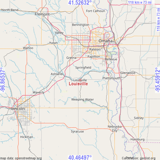
Louisville GPS coordinates[2]
40° 59' 52.008" North, 96° 9' 44.064" West
| Map corner | latitude | longitude |
|---|---|---|
| Upper-left | 41.52632°, | -96.86537° |
| Center: | 40.99778°, | -96.16224° |
| Lower-right: | 40.46497°, | -95.45912° |
| Map W x H: | 118×118 km | = 73.3×73.3mi |
| max Lat: | 71.29058° ⇑34.2% North |
| Louisville: | 40.99778° |
| min Lat: | ⇓65.8% South 19.06759° |
| min Long | Louisville | max Long |
| -171.73463° | -96.16224° | -66.98998° |
| W 26.2%⇐ | ⇒73.8% E |
Elevation
Elevation of Louisville is 325 m = 1066 ft, and this is 30.2 m = 99 ft above average elevation for this country.
| Max E: |
3189 m = 10463 ft | 23.4% |
| Louisville | 325 m 1066 ft | |
| Avg. | 294.8 m = 967 ft | |
Min E: |
-60 m = -197 ft | 76.6% |
See also: United States elevation on elevation.city.
Geographical zone
Louisville is located in North temperate zone (between Tropic of Cancer and the Arctic Circle). Distance of this Northern Tropic circle is 1952.6 km =1213.3 mi to South.| Distance of | km | miles | from Louisville |
|---|---|---|---|
| North Pole | 5448.5 | 3385.5 | to North |
| Arctic Circle | 2842.6 | 1766.3 | to North |
| Tropic Cancer | 1952.6 | 1213.3 | to South |
| Equator | 4558.5 | 2832.5 | to South |


Nearby cities:
15 places around Louisville: (largest is in red/bold)
• Ashland
17.9 km =11.1 mi,  284°
284°
• Bellevue
27.5 km =17.1 mi,  55°
55°
• Boys Town
29.4 km =18.3 mi,  4°
4°
• Chalco
20.7 km =12.9 mi, 2°
• Eagle
30.2 km =18.8 mi,  228°
228°
• Elmwood
20.6 km =12.8 mi,  212°
212°
• Greenwood
23.7 km =14.7 mi,  260°
260°
• Gretna
17.2 km =10.7 mi,  337°
337°
• La Vista
23.4 km =14.5 mi,  27°
27°
• Offutt Air Force Base
24.4 km =15.2 mi, 56°
• Papillion
20.1 km =12.5 mi, 30°
• Plattsmouth
23.5 km =14.6 mi,  86°
86°
• Ralston
25.2 km =15.7 mi,  23°
23°
• Springfield
9.6 km =6 mi,  13°
13°
• Weeping Water
14.3 km =8.9 mi,  172°
172°
Sources, notices
• [Note1] Compared only with cities in United States existing in our database
• [Src1] Map data: © OpenStreetMap contributors (CC-BY-SA)
• [Src2] Other city data from geonames.org with taken over terms of usage.
• [Src3] Geographical zone / Annual Mean Temperature by Robert A. Rohde @ Wikipedia
