Springfield geodata
Springfield (Nebraska) is a populated place; located in United States in America/Chicago (GMT-5) time zone. With population of 1,584 people, there are 13344 cities with bigger population in this country. Compared to other cities in United States, 66.7% of cities are located further ↓South; 73.7% of cities are located further →East and 77.3% of cities have lower elevation than Springfield. Note1


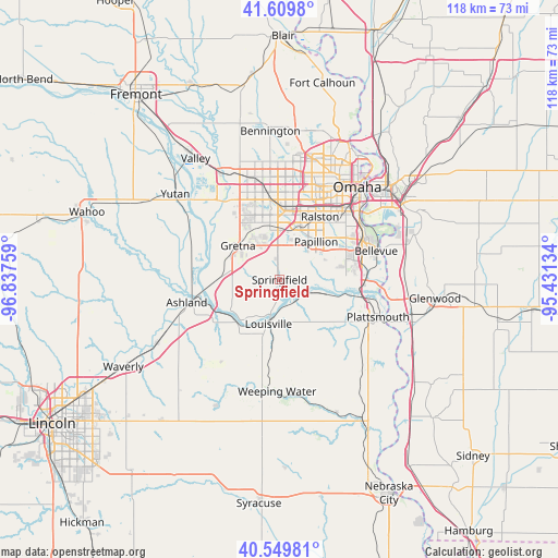
Springfield GPS coordinates[2]
41° 4' 54.984" North, 96° 8' 4.056" West
| Map corner | latitude | longitude |
|---|---|---|
| Upper-left | 41.6098°, | -96.83759° |
| Center: | 41.08194°, | -96.13446° |
| Lower-right: | 40.54981°, | -95.43134° |
| Map W x H: | 117.9×117.9 km | = 73.3×73.3mi |
| max Lat: | 71.29058° ⇑33.3% North |
| Springfield: | 41.08194° |
| min Lat: | ⇓66.7% South 19.06759° |
| min Long | Springfield | max Long |
| -171.73463° | -96.13446° | -66.98998° |
| W 26.3%⇐ | ⇒73.7% E |
Elevation
Elevation of Springfield is 330 m = 1083 ft, and this is 35.2 m = 115 ft above average elevation for this country.
| Max E: |
3189 m = 10463 ft | 22.7% |
| Springfield | 330 m 1083 ft | |
| Avg. | 294.8 m = 967 ft | |
Min E: |
-60 m = -197 ft | 77.3% |
See also: United States elevation on elevation.city.
Geographical zone
Springfield is located in North temperate zone (between Tropic of Cancer and the Arctic Circle). Distance of this Northern Tropic circle is 1962 km =1219.1 mi to South.| Distance of | km | miles | from Springfield |
|---|---|---|---|
| North Pole | 5439.2 | 3379.8 | to North |
| Arctic Circle | 2833.3 | 1760.5 | to North |
| Tropic Cancer | 1962 | 1219.1 | to South |
| Equator | 4567.9 | 2838.4 | to South |


Nearby cities:
15 places around Springfield: (largest is in red/bold)
• Ashland
20.2 km =12.6 mi,  256°
256°
• Bellevue
21.3 km =13.2 mi,  73°
73°
• Boys Town
19.9 km =12.4 mi,  0°
0°
• Chalco
11.4 km =7.1 mi,  353°
353°
• Elkhorn
24.2 km =15 mi,  339°
339°
• Gretna
11 km =6.8 mi,  306°
306°
• La Vista
14.3 km =8.9 mi,  37°
37°
• Louisville
9.6 km =6 mi,  193°
193°
• Offutt Air Force Base
18.4 km =11.4 mi,  76°
76°
• Omaha
25.3 km =15.7 mi, 39°
• Papillion
11.2 km =7 mi, 43°
• Plattsmouth
22.6 km =14 mi,  110°
110°
• Ralston
15.7 km =9.8 mi,  29°
29°
• Waterloo
26.1 km =16.2 mi,  330°
330°
• Weeping Water
23.6 km =14.7 mi,  181°
181°
Sources, notices
• [Note1] Compared only with cities in United States existing in our database
• [Src1] Map data: © OpenStreetMap contributors (CC-BY-SA)
• [Src2] Other city data from geonames.org with taken over terms of usage.
• [Src3] Geographical zone / Annual Mean Temperature by Robert A. Rohde @ Wikipedia
