Bellevue geodata
Bellevue (Nebraska) is a populated place; located in United States in America/Chicago (GMT-5) time zone. With population of 55,510 people, there are 829 cities with bigger population in this country. Compared to other cities in United States, 67.2% of cities are located further ↓South; 73.2% of cities are located further →East and 75% of cities have lower elevation than Bellevue. Note1


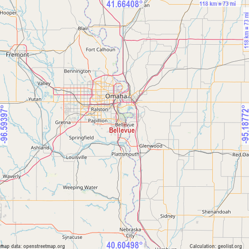
Bellevue GPS coordinates[2]
41° 8' 12.012" North, 95° 53' 27.024" West
| Map corner | latitude | longitude |
|---|---|---|
| Upper-left | 41.66408°, | -96.59397° |
| Center: | 41.13667°, | -95.89084° |
| Lower-right: | 40.60498°, | -95.18772° |
| Map W x H: | 117.8×117.8 km | = 73.2×73.2mi |
| max Lat: | 71.29058° ⇑32.8% North |
| Bellevue: | 41.13667° |
| min Lat: | ⇓67.2% South 19.06759° |
| min Long | Bellevue | max Long |
| -171.73463° | -95.89084° | -66.98998° |
| W 26.8%⇐ | ⇒73.2% E |
Elevation
Elevation of Bellevue is 313 m = 1027 ft, and this is 18.2 m = 60 ft above average elevation for this country.
| Max E: |
3189 m = 10463 ft | 25% |
| Bellevue | 313 m 1027 ft | |
| Avg. | 294.8 m = 967 ft | |
Min E: |
-60 m = -197 ft | 75% |
See also: Bellevue elevation on elevation.city.
Geographical zone
Bellevue is located in North temperate zone (between Tropic of Cancer and the Arctic Circle). Distance of this Northern Tropic circle is 1968 km =1222.9 mi to South.| Distance of | km | miles | from Bellevue |
|---|---|---|---|
| North Pole | 5433.1 | 3376 | to North |
| Arctic Circle | 2827.2 | 1756.7 | to North |
| Tropic Cancer | 1968 | 1222.9 | to South |
| Equator | 4574 | 2842.2 | to South |


Nearby cities:
15 places around Bellevue: (largest is in red/bold)
• Boys Town
24.5 km =15.2 mi,  304°
304°
• Carter Lake
17.3 km =10.7 mi,  352°
352°
• Chalco
22.3 km =13.9 mi,  283°
283°
• Council Bluffs
14.2 km =8.8 mi,  10°
10°
• Crescent
25.5 km =15.8 mi, 6°
• Glenwood
15.9 km =9.9 mi,  128°
128°
• La Vista
12.9 km =8 mi,  294°
294°
• Louisville
27.5 km =17.1 mi,  235°
235°
• Offutt Air Force Base
3.1 km =1.9 mi,  234°
234°
• Omaha
13.9 km =8.6 mi,  342°
342°
• Papillion
12.8 km =8 mi, 278°
• Plattsmouth
13.9 km =8.6 mi,  177°
177°
• Ralston
14.8 km =9.2 mi, 301°
• Springfield
21.3 km =13.2 mi,  253°
253°
• Treynor
25.6 km =15.9 mi,  65°
65°
Sources, notices
• [Note1] Compared only with cities in United States existing in our database
• [Src1] Map data: © OpenStreetMap contributors (CC-BY-SA)
• [Src2] Other city data from geonames.org with taken over terms of usage.
• [Src3] Geographical zone / Annual Mean Temperature by Robert A. Rohde @ Wikipedia
