Palmyra geodata
Palmyra (Nebraska) is a populated place; located in United States in America/Chicago (GMT-5) time zone. With population of 559 people, there are 20165 cities with bigger population in this country. Compared to other cities in United States, 61.6% of cities are located further ↓South; 74.2% of cities are located further →East and 80% of cities have lower elevation than Palmyra. Note1


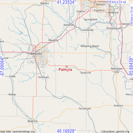
Palmyra GPS coordinates[2]
40° 42' 16.02" North, 96° 23' 15.036" West
| Map corner | latitude | longitude |
|---|---|---|
| Upper-left | 41.23534°, | -97.09064° |
| Center: | 40.70445°, | -96.38751° |
| Lower-right: | 40.16929°, | -95.68439° |
| Map W x H: | 118.5×118.5 km | = 73.6×73.6mi |
| max Lat: | 71.29058° ⇑38.4% North |
| Palmyra: | 40.70445° |
| min Lat: | ⇓61.6% South 19.06759° |
| min Long | Palmyra | max Long |
| -171.73463° | -96.38751° | -66.98998° |
| W 25.8%⇐ | ⇒74.2% E |
Elevation
Elevation of Palmyra is 353 m = 1158 ft, and this is 58.2 m = 191 ft above average elevation for this country.
| Max E: |
3189 m = 10463 ft | 20% |
| Palmyra | 353 m 1158 ft | |
| Avg. | 294.8 m = 967 ft | |
Min E: |
-60 m = -197 ft | 80% |
See also: United States elevation on elevation.city.
Geographical zone
Palmyra is located in North temperate zone (between Tropic of Cancer and the Arctic Circle). Distance of this Northern Tropic circle is 1920 km =1193 mi to South.| Distance of | km | miles | from Palmyra |
|---|---|---|---|
| North Pole | 5481.2 | 3405.9 | to North |
| Arctic Circle | 2875.3 | 1786.6 | to North |
| Tropic Cancer | 1920 | 1193 | to South |
| Equator | 4525.9 | 2812.3 | to South |


Nearby cities:
15 places around Palmyra: (largest is in red/bold)
• Adams
29.1 km =18.1 mi,  200°
200°
• Ashland
37.3 km =23.2 mi,  2°
2°
• Bennet
10.4 km =6.5 mi,  254°
254°
• Eagle
13 km =8.1 mi,  343°
343°
• Elmwood
17.2 km =10.7 mi,  27°
27°
• Firth
26.6 km =16.5 mi,  223°
223°
• Greenwood
29.1 km =18.1 mi,  351°
351°
• Hickman
22.4 km =13.9 mi, 245°
• Lincoln
25.8 km =16 mi,  294°
294°
• Louisville
37.7 km =23.4 mi, 30°
• Nebraska City
44.7 km =27.8 mi,  93°
93°
• Syracuse
17.8 km =11.1 mi,  107°
107°
• Tecumseh
40.9 km =25.4 mi,  156°
156°
• Waverly
26.5 km =16.5 mi,  333°
333°
• Weeping Water
27.8 km =17.3 mi,  48°
48°
Sources, notices
• [Note1] Compared only with cities in United States existing in our database
• [Src1] Map data: © OpenStreetMap contributors (CC-BY-SA)
• [Src2] Other city data from geonames.org with taken over terms of usage.
• [Src3] Geographical zone / Annual Mean Temperature by Robert A. Rohde @ Wikipedia
