Newark geodata
Newark (New Jersey) is a seat of a second-order administrative division; located in United States in America/New_York (GMT-4) time zone. With population of 281,944 people, there are 78 cities with bigger population in this country. Compared to other cities in United States, 62.1% of cities are located further ↓South; 89.6% of cities are located further ←West and 87.4% of cities have higher elevation than Newark. Note1


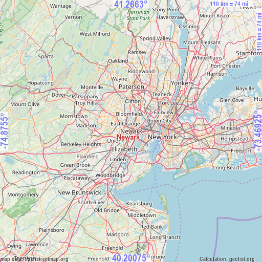
Newark GPS coordinates[2]
40° 44' 8.376" North, 74° 10' 20.532" West
| Map corner | latitude | longitude |
|---|---|---|
| Upper-left | 41.2663°, | -74.8755° |
| Center: | 40.73566°, | -74.17237° |
| Lower-right: | 40.20075°, | -73.46925° |
| Map W x H: | 118.5×118.5 km | = 73.6×73.6mi |
| max Lat: | 71.29058° ⇑37.9% North |
| Newark: | 40.73566° |
| min Lat: | ⇓62.1% South 19.06759° |
| min Long | Newark | max Long |
| -171.73463° | -74.17237° | -66.98998° |
| W 89.6%⇐ | ⇒10.4% E |
Elevation
Elevation of Newark is 22 m = 72 ft, and this is 272.8 m = 895 ft below average elevation for this country.
| Max E: |
3189 m = 10463 ft | 87.4% |
| Avg. | 294.8 m = 967 ft | |
| Newark | 22 m = 72 ft | |
Min E: |
-60 m = -197 ft | 12.6% |
See also: Newark elevation on elevation.city.
Geographical zone
Newark is located in North temperate zone (between Tropic of Cancer and the Arctic Circle). Distance of this Northern Tropic circle is 1923.5 km =1195.2 mi to South.| Distance of | km | miles | from Newark |
|---|---|---|---|
| North Pole | 5477.7 | 3403.7 | to North |
| Arctic Circle | 2871.8 | 1784.5 | to North |
| Tropic Cancer | 1923.5 | 1195.2 | to South |
| Equator | 4529.4 | 2814.4 | to South |


Nearby cities:
15 places around Newark: (largest is in red/bold)
• Belleville
6.7 km =4.2 mi,  16°
16°
• Bloomfield
8 km =5 mi,  352°
352°
• East Newark
1.7 km =1.1 mi,  32°
32°
• East Orange
4.5 km =2.8 mi,  322°
322°
• Elizabeth
8.6 km =5.3 mi,  202°
202°
• Glen Ridge
8.2 km =5.1 mi,  341°
341°
• Harrison
1.8 km =1.1 mi,  48°
48°
• Hillside
6.2 km =3.9 mi,  231°
231°
• Irvington
5.3 km =3.3 mi,  265°
265°
• Jersey City
8 km =5 mi,  95°
95°
• Kearny
4.3 km =2.7 mi, 31°
• Maplewood
8.5 km =5.3 mi, 266°
• North Arlington
6.7 km =4.2 mi, 29°
• Orange
6.4 km =4 mi,  307°
307°
• South Orange
7.6 km =4.7 mi,  281°
281°
Sources, notices
• [Note1] Compared only with cities in United States existing in our database
• [Src1] Map data: © OpenStreetMap contributors (CC-BY-SA)
• [Src2] Other city data from geonames.org with taken over terms of usage.
• [Src3] Geographical zone / Annual Mean Temperature by Robert A. Rohde @ Wikipedia
