Boonton geodata
Boonton (New Jersey) is a populated place; located in United States in America/New_York (GMT-4) time zone. With population of 8,441 people, there are 5053 cities with bigger population in this country. Compared to other cities in United States, 64.8% of cities are located further ↓South; 88.7% of cities are located further ←West and 65.6% of cities have higher elevation than Boonton. Note1


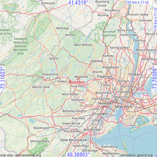
Boonton GPS coordinates[2]
40° 54' 9.36" North, 74° 24' 25.56" West
| Map corner | latitude | longitude |
|---|---|---|
| Upper-left | 41.4319°, | -75.11023° |
| Center: | 40.9026°, | -74.4071° |
| Lower-right: | 40.36903°, | -73.70398° |
| Map W x H: | 118.2×118.2 km | = 73.4×73.4mi |
| max Lat: | 71.29058° ⇑35.2% North |
| Boonton: | 40.9026° |
| min Lat: | ⇓64.8% South 19.06759° |
| min Long | Boonton | max Long |
| -171.73463° | -74.4071° | -66.98998° |
| W 88.7%⇐ | ⇒11.3% E |
Elevation
Elevation of Boonton is 125 m = 410 ft, and this is 169.8 m = 557 ft below average elevation for this country.
| Max E: |
3189 m = 10463 ft | 65.6% |
| Avg. | 294.8 m = 967 ft | |
| Boonton | 125 m = 410 ft | |
Min E: |
-60 m = -197 ft | 34.4% |
See also: United States elevation on elevation.city.
Geographical zone
Boonton is located in North temperate zone (between Tropic of Cancer and the Arctic Circle). Distance of this Northern Tropic circle is 1942 km =1206.7 mi to South.| Distance of | km | miles | from Boonton |
|---|---|---|---|
| North Pole | 5459.1 | 3392.1 | to North |
| Arctic Circle | 2853.2 | 1772.9 | to North |
| Tropic Cancer | 1942 | 1206.7 | to South |
| Equator | 4547.9 | 2825.9 | to South |


Nearby cities:
15 places around Boonton: (largest is in red/bold)
• East Hanover
9.8 km =6.1 mi,  158°
158°
• Fairfield
8.8 km =5.5 mi,  103°
103°
• Hanover
11.4 km =7.1 mi, 162°
• Kinnelon
11.5 km =7.1 mi,  16°
16°
• Lake Telemark
9.7 km =6 mi,  308°
308°
• Lincoln Park
9.1 km =5.7 mi,  74°
74°
• Morris Plains
10.9 km =6.8 mi,  214°
214°
• Mountain Lakes
2.3 km =1.4 mi,  248°
248°
• Parsippany
5.2 km =3.2 mi,  197°
197°
• Rockaway
9 km =5.6 mi,  269°
269°
• Victory Gardens
11.8 km =7.3 mi,  255°
255°
• Wayne
11.3 km =7 mi,  76°
76°
• West Caldwell
11 km =6.8 mi,  122°
122°
• Westville
11.1 km =6.9 mi,  125°
125°
• White Meadow Lake
9 km =5.6 mi,  285°
285°
Sources, notices
• [Note1] Compared only with cities in United States existing in our database
• [Src1] Map data: © OpenStreetMap contributors (CC-BY-SA)
• [Src2] Other city data from geonames.org with taken over terms of usage.
• [Src3] Geographical zone / Annual Mean Temperature by Robert A. Rohde @ Wikipedia
