Sparta geodata
Sparta (New Jersey) is a populated place; located in United States in America/New_York (GMT-4) time zone. With population of 19,722 people, there are 2553 cities with bigger population in this country. Compared to other cities in United States, 66.3% of cities are located further ↓South; 88.1% of cities are located further ←West and 57.2% of cities have lower elevation than Sparta. Note1


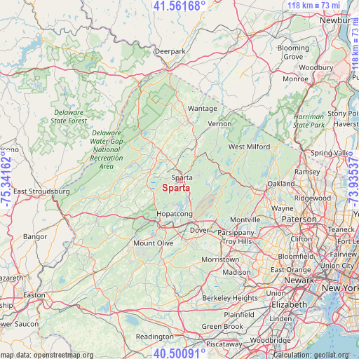
Sparta GPS coordinates[2]
41° 2' 0.348" North, 74° 38' 18.564" West
| Map corner | latitude | longitude |
|---|---|---|
| Upper-left | 41.56168°, | -75.34162° |
| Center: | 41.03343°, | -74.63849° |
| Lower-right: | 40.50091°, | -73.93537° |
| Map W x H: | 117.9×117.9 km | = 73.3×73.3mi |
| max Lat: | 71.29058° ⇑33.7% North |
| Sparta: | 41.03343° |
| min Lat: | ⇓66.3% South 19.06759° |
| min Long | Sparta | max Long |
| -171.73463° | -74.63849° | -66.98998° |
| W 88.1%⇐ | ⇒11.9% E |
Elevation
Elevation of Sparta is 227 m = 745 ft, and this is 67.8 m = 222 ft below average elevation for this country.
| Max E: |
3189 m = 10463 ft | 42.8% |
| Avg. | 294.8 m = 967 ft | |
| Sparta | 227 m = 745 ft | |
Min E: |
-60 m = -197 ft | 57.2% |
See also: United States elevation on elevation.city.
Geographical zone
Sparta is located in North temperate zone (between Tropic of Cancer and the Arctic Circle). Distance of this Northern Tropic circle is 1956.6 km =1215.8 mi to South.| Distance of | km | miles | from Sparta |
|---|---|---|---|
| North Pole | 5444.6 | 3383.1 | to North |
| Arctic Circle | 2838.7 | 1763.9 | to North |
| Tropic Cancer | 1956.6 | 1215.8 | to South |
| Equator | 4562.5 | 2835 | to South |


Nearby cities:
15 places around Sparta: (largest is in red/bold)
• Andover
10.2 km =6.3 mi,  238°
238°
• Branchville
15.8 km =9.8 mi,  322°
322°
• Franklin
11 km =6.8 mi,  26°
26°
• Hamburg
14.3 km =8.9 mi,  21°
21°
• Hopatcong
11.3 km =7 mi,  188°
188°
• Hopatcong Hills
10.3 km =6.4 mi,  195°
195°
• Lake Mohawk
2.5 km =1.6 mi,  227°
227°
• Lake Telemark
14.6 km =9.1 mi,  125°
125°
• Landing
14.4 km =8.9 mi, 188°
• Mount Arlington
12 km =7.5 mi,  178°
178°
• Netcong
16 km =9.9 mi, 200°
• Newton
10 km =6.2 mi,  286°
286°
• Ogdensburg
6.6 km =4.1 mi,  35°
35°
• Stanhope
15.7 km =9.8 mi, 202°
• White Meadow Lake
16.2 km =10.1 mi,  138°
138°
Sources, notices
• [Note1] Compared only with cities in United States existing in our database
• [Src1] Map data: © OpenStreetMap contributors (CC-BY-SA)
• [Src2] Other city data from geonames.org with taken over terms of usage.
• [Src3] Geographical zone / Annual Mean Temperature by Robert A. Rohde @ Wikipedia
