Vista Center geodata
Vista Center (New Jersey) is a populated place; located in United States in America/New_York (GMT-4) time zone. With population of 2,095 people, there are 11636 cities with bigger population in this country. Compared to other cities in United States, 55.2% of cities are located further ↓South; 89% of cities are located further ←West and 80.9% of cities have higher elevation than Vista Center. Note1


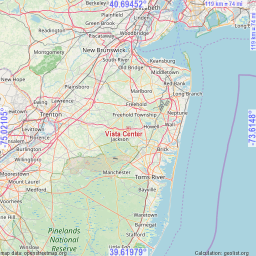
Vista Center GPS coordinates[2]
40° 9' 33.408" North, 74° 19' 4.512" West
| Map corner | latitude | longitude |
|---|---|---|
| Upper-left | 40.69452°, | -75.02105° |
| Center: | 40.15928°, | -74.31792° |
| Lower-right: | 39.61979°, | -73.6148° |
| Map W x H: | 119.5×119.5 km | = 74.3×74.3mi |
| max Lat: | 71.29058° ⇑44.8% North |
| Vista Center: | 40.15928° |
| min Lat: | ⇓55.2% South 19.06759° |
| min Long | Vista Center | max Long |
| -171.73463° | -74.31792° | -66.98998° |
| W 89%⇐ | ⇒11% E |
Elevation
Elevation of Vista Center is 43 m = 141 ft, and this is 251.8 m = 826 ft below average elevation for this country.
| Max E: |
3189 m = 10463 ft | 80.9% |
| Avg. | 294.8 m = 967 ft | |
| Vista Center | 43 m = 141 ft | |
Min E: |
-60 m = -197 ft | 19.1% |
See also: United States elevation on elevation.city.
Geographical zone
Vista Center is located in North temperate zone (between Tropic of Cancer and the Arctic Circle). Distance of this Northern Tropic circle is 1859.4 km =1155.4 mi to South.| Distance of | km | miles | from Vista Center |
|---|---|---|---|
| North Pole | 5541.8 | 3443.5 | to North |
| Arctic Circle | 2935.9 | 1824.3 | to North |
| Tropic Cancer | 1859.4 | 1155.4 | to South |
| Equator | 4465.3 | 2774.6 | to South |


Nearby cities:
15 places around Vista Center: (largest is in red/bold)
• Cedar Glen West
13.2 km =8.2 mi,  170°
170°
• East Freehold
14.7 km =9.1 mi,  22°
22°
• Englishtown
15.7 km =9.8 mi,  347°
347°
• Farmingdale
13.4 km =8.3 mi,  71°
71°
• Freehold
11.8 km =7.3 mi, 18°
• Lakehurst
16.1 km =10 mi,  177°
177°
• Lakewood
10.9 km =6.8 mi,  128°
128°
• Leisure Knoll
15.8 km =9.8 mi, 171°
• Leisure Village
17.2 km =10.7 mi,  138°
138°
• Leisure Village West-Pine Lake Park
17.8 km =11.1 mi, 165°
• Pine Lake Park
18.1 km =11.2 mi,  163°
163°
• Ramtown
15.4 km =9.6 mi,  106°
106°
• Roosevelt
14.8 km =9.2 mi,  297°
297°
• West Freehold
9.3 km =5.8 mi,  8°
8°
• Yorketown
16.6 km =10.3 mi, 354°
Sources, notices
• [Note1] Compared only with cities in United States existing in our database
• [Src1] Map data: © OpenStreetMap contributors (CC-BY-SA)
• [Src2] Other city data from geonames.org with taken over terms of usage.
• [Src3] Geographical zone / Annual Mean Temperature by Robert A. Rohde @ Wikipedia
