Wayne geodata
Wayne (New Jersey) is a populated place; located in United States in America/New_York (GMT-4) time zone. With population of 57,915 people, there are 787 cities with bigger population in this country. Compared to other cities in United States, 65% of cities are located further ↓South; 89.2% of cities are located further ←West and 77.9% of cities have higher elevation than Wayne. Note1


Wayne GPS coordinates[2]
40° 55' 31.368" North, 74° 16' 35.544" West
| Map corner | latitude | longitude |
|---|---|---|
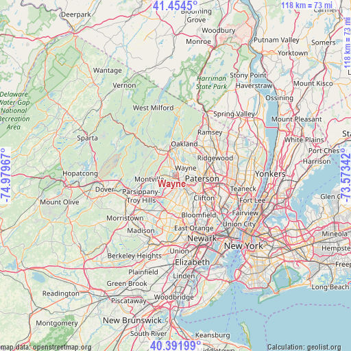
| Upper-left | 41.4545°, | -74.97967° |
| Center: | 40.92538°, | -74.27654° |
| Lower-right: | 40.39199°, | -73.57342° |
| Map W x H: | 118.1×118.1 km | = 73.4×73.4mi |
| max Lat: | 71.29058° ⇑35% North |
| Wayne: | 40.92538° |
| min Lat: | ⇓65% South 19.06759° |
| min Long | Wayne | max Long |
| -171.73463° | -74.27654° | -66.98998° |
| W 89.2%⇐ | ⇒10.8% E |
Elevation
Elevation of Wayne is 56 m = 184 ft, and this is 238.8 m = 783 ft below average elevation for this country.
| Max E: |
3189 m = 10463 ft | 77.9% |
| Avg. | 294.8 m = 967 ft | |
| Wayne | 56 m = 184 ft | |
Min E: |
-60 m = -197 ft | 22.1% |
See also: Wayne elevation on elevation.city.
Geographical zone
Wayne is located in North temperate zone (between Tropic of Cancer and the Arctic Circle). Distance of this Northern Tropic circle is 1944.6 km =1208.3 mi to South.| Distance of | km | miles | from Wayne |
|---|---|---|---|
| North Pole | 5456.6 | 3390.6 | to North |
| Arctic Circle | 2850.7 | 1771.3 | to North |
| Tropic Cancer | 1944.6 | 1208.3 | to South |
| Equator | 4550.5 | 2827.5 | to South |


Nearby cities:
15 places around Wayne: (largest is in red/bold)
• Cedar Grove
9.1 km =5.7 mi,  153°
153°
• Fairfield
5.3 km =3.3 mi,  208°
208°
• Haledon
7.7 km =4.8 mi,  81°
81°
• Lincoln Park
2.2 km =1.4 mi,  266°
266°
• Little Falls
8.5 km =5.3 mi,  137°
137°
• North Caldwell
6.9 km =4.3 mi,  167°
167°
• North Haledon
8.3 km =5.2 mi,  66°
66°
• Paterson
8.9 km =5.5 mi,  96°
96°
• Pompton Lakes
9 km =5.6 mi,  352°
352°
• Prospect Park
8.7 km =5.4 mi, 81°
• Riverdale
8 km =5 mi,  343°
343°
• Singac
5.2 km =3.2 mi, 145°
• Totowa
6 km =3.7 mi,  111°
111°
• West Caldwell
8.7 km =5.4 mi,  191°
191°
• Woodland Park
7.9 km =4.9 mi,  119°
119°
Sources, notices
• [Note1] Compared only with cities in United States existing in our database
• [Src1] Map data: © OpenStreetMap contributors (CC-BY-SA)
• [Src2] Other city data from geonames.org with taken over terms of usage.
• [Src3] Geographical zone / Annual Mean Temperature by Robert A. Rohde @ Wikipedia
