Albany geodata
Albany (New York) is a seat of a first-order administrative division; located in United States in America/New_York (GMT-4) time zone. With population of 98,469 people, there are 358 cities with bigger population in this country. Compared to other cities in United States, 80.9% of cities are located further ↓South; 91.8% of cities are located further ←West and 79.3% of cities have higher elevation than Albany. Note1


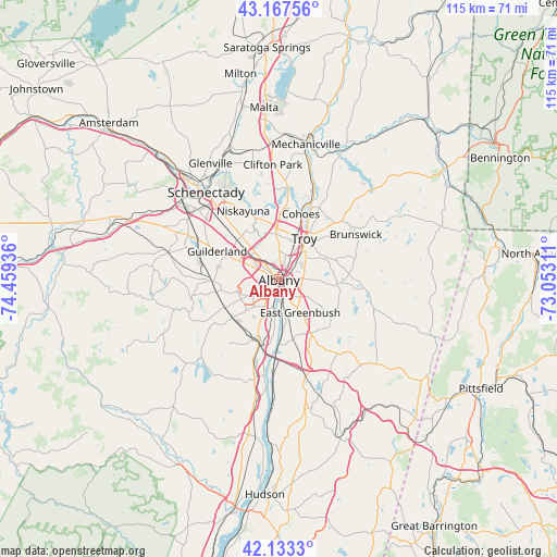
Albany GPS coordinates[2]
42° 39' 9.288" North, 73° 45' 22.428" West
| Map corner | latitude | longitude |
|---|---|---|
| Upper-left | 43.16756°, | -74.45936° |
| Center: | 42.65258°, | -73.75623° |
| Lower-right: | 42.1333°, | -73.05311° |
| Map W x H: | 115×115 km | = 71.5×71.5mi |
| max Lat: | 71.29058° ⇑19.1% North |
| Albany: | 42.65258° |
| min Lat: | ⇓80.9% South 19.06759° |
| min Long | Albany | max Long |
| -171.73463° | -73.75623° | -66.98998° |
| W 91.8%⇐ | ⇒8.2% E |
Elevation
Elevation of Albany is 50 m = 164 ft, and this is 244.8 m = 803 ft below average elevation for this country.
| Max E: |
3189 m = 10463 ft | 79.3% |
| Avg. | 294.8 m = 967 ft | |
| Albany | 50 m = 164 ft | |
Min E: |
-60 m = -197 ft | 20.7% |
See also: Albany elevation on elevation.city.
Geographical zone
Albany is located in North temperate zone (between Tropic of Cancer and the Arctic Circle). Distance of this Northern Tropic circle is 2136.6 km =1327.6 mi to South.| Distance of | km | miles | from Albany |
|---|---|---|---|
| North Pole | 5264.5 | 3271.2 | to North |
| Arctic Circle | 2658.7 | 1652 | to North |
| Tropic Cancer | 2136.6 | 1327.6 | to South |
| Equator | 4742.5 | 2946.9 | to South |


Nearby cities:
15 places around Albany: (largest is in red/bold)
• Colonie
9.6 km =6 mi,  318°
318°
• Delmar
7.1 km =4.4 mi,  241°
241°
• East Greenbush
8.2 km =5.1 mi,  146°
146°
• Green Island
11.5 km =7.1 mi,  27°
27°
• Hampton Manor
4.2 km =2.6 mi, 147°
• Latham
10.5 km =6.5 mi,  358°
358°
• McKownville
8.2 km =5.1 mi,  295°
295°
• Menands
5.1 km =3.2 mi, 30°
• Rensselaer
1.6 km =1 mi,  135°
135°
• Roessleville
6.3 km =3.9 mi, 318°
• Troy
9.9 km =6.2 mi, 31°
• Watervliet
9.7 km =6 mi, 27°
• West Albany
3.9 km =2.4 mi,  331°
331°
• Westmere
10.1 km =6.3 mi, 295°
• Wynantskill
10.4 km =6.5 mi,  61°
61°
Sources, notices
• [Note1] Compared only with cities in United States existing in our database
• [Src1] Map data: © OpenStreetMap contributors (CC-BY-SA)
• [Src2] Other city data from geonames.org with taken over terms of usage.
• [Src3] Geographical zone / Annual Mean Temperature by Robert A. Rohde @ Wikipedia
