Hampton Manor geodata
Hampton Manor (New York) is a populated place; located in United States in America/New_York (GMT-4) time zone. With population of 2,417 people, there are 10808 cities with bigger population in this country. Compared to other cities in United States, 80.7% of cities are located further ↓South; 91.9% of cities are located further ←West and 76.9% of cities have higher elevation than Hampton Manor. Note1
Administrative division(s):
- Level 1: New York
- Level 2: Rensselaer County
- Level 3: Town of East Greenbush


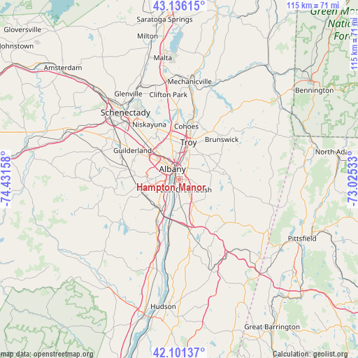
Hampton Manor GPS coordinates[2]
42° 37' 15.276" North, 73° 43' 42.42" West
| Map corner | latitude | longitude |
|---|---|---|
| Upper-left | 43.13615°, | -74.43158° |
| Center: | 42.62091°, | -73.72845° |
| Lower-right: | 42.10137°, | -73.02533° |
| Map W x H: | 115.1×115.1 km | = 71.5×71.5mi |
| max Lat: | 71.29058° ⇑19.3% North |
| Hampton Manor: | 42.62091° |
| min Lat: | ⇓80.7% South 19.06759° |
| min Long | Hampton Manor | max Long |
| -171.73463° | -73.72845° | -66.98998° |
| W 91.9%⇐ | ⇒8.1% E |
Elevation
Elevation of Hampton Manor is 61 m = 200 ft, and this is 233.8 m = 767 ft below average elevation for this country.
| Max E: |
3189 m = 10463 ft | 76.9% |
| Avg. | 294.8 m = 967 ft | |
| Hampton Manor | 61 m = 200 ft | |
Min E: |
-60 m = -197 ft | 23.1% |
See also: United States elevation on elevation.city.
Geographical zone
Hampton Manor is located in North temperate zone (between Tropic of Cancer and the Arctic Circle). Distance of this Northern Tropic circle is 2133.1 km =1325.4 mi to South.| Distance of | km | miles | from Hampton Manor |
|---|---|---|---|
| North Pole | 5268.1 | 3273.4 | to North |
| Arctic Circle | 2662.2 | 1654.2 | to North |
| Tropic Cancer | 2133.1 | 1325.4 | to South |
| Equator | 4739 | 2944.7 | to South |


Nearby cities:
15 places around Hampton Manor: (largest is in red/bold)
• Albany
4.2 km =2.6 mi,  327°
327°
• Castleton-on-Hudson
11.5 km =7.1 mi,  189°
189°
• Colonie
13.8 km =8.6 mi,  321°
321°
• Delmar
8.5 km =5.3 mi,  270°
270°
• East Greenbush
4 km =2.5 mi,  146°
146°
• McKownville
12 km =7.5 mi,  305°
305°
• Menands
7.9 km =4.9 mi,  2°
2°
• Rensselaer
2.7 km =1.7 mi, 333°
• Roessleville
10.5 km =6.5 mi, 322°
• Troy
12.3 km =7.6 mi,  14°
14°
• Watervliet
12.3 km =7.6 mi, 10°
• West Albany
8 km =5 mi, 329°
• West Sand Lake
10.1 km =6.3 mi,  75°
75°
• Westmere
13.9 km =8.6 mi,  304°
304°
• Wynantskill
10.9 km =6.8 mi,  39°
39°
Sources, notices
• [Note1] Compared only with cities in United States existing in our database
• [Src1] Map data: © OpenStreetMap contributors (CC-BY-SA)
• [Src2] Other city data from geonames.org with taken over terms of usage.
• [Src3] Geographical zone / Annual Mean Temperature by Robert A. Rohde @ Wikipedia
