Troy geodata
Troy (New York) is a seat of a second-order administrative division; located in United States in America/New_York (GMT-4) time zone. With population of 49,906 people, there are 954 cities with bigger population in this country. Compared to other cities in United States, 81.4% of cities are located further ↓South; 92.1% of cities are located further ←West and 89.5% of cities have higher elevation than Troy. Note1


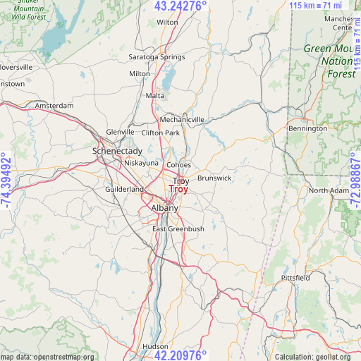
Troy GPS coordinates[2]
42° 43' 42.276" North, 73° 41' 30.444" West
| Map corner | latitude | longitude |
|---|---|---|
| Upper-left | 43.24276°, | -74.39492° |
| Center: | 42.72841°, | -73.69179° |
| Lower-right: | 42.20976°, | -72.98867° |
| Map W x H: | 114.9×114.9 km | = 71.4×71.4mi |
| max Lat: | 71.29058° ⇑18.6% North |
| Troy: | 42.72841° |
| min Lat: | ⇓81.4% South 19.06759° |
| min Long | Troy | max Long |
| -171.73463° | -73.69179° | -66.98998° |
| W 92.1%⇐ | ⇒7.9% E |
Elevation
Elevation of Troy is 17 m = 56 ft, and this is 277.8 m = 911 ft below average elevation for this country.
| Max E: |
3189 m = 10463 ft | 89.5% |
| Avg. | 294.8 m = 967 ft | |
| Troy | 17 m = 56 ft | |
Min E: |
-60 m = -197 ft | 10.5% |
See also: Troy elevation on elevation.city.
Geographical zone
Troy is located in North temperate zone (between Tropic of Cancer and the Arctic Circle). Distance of this Northern Tropic circle is 2145 km =1332.8 mi to South.| Distance of | km | miles | from Troy |
|---|---|---|---|
| North Pole | 5256.1 | 3266 | to North |
| Arctic Circle | 2650.2 | 1646.8 | to North |
| Tropic Cancer | 2145 | 1332.8 | to South |
| Equator | 4751 | 2952.1 | to South |


Nearby cities:
15 places around Troy: (largest is in red/bold)
• Albany
9.9 km =6.2 mi,  211°
211°
• Cohoes
5.1 km =3.2 mi,  352°
352°
• Colonie
11.6 km =7.2 mi,  264°
264°
• Green Island
1.8 km =1.1 mi,  0°
0°
• Hampton Manor
12.3 km =7.6 mi,  194°
194°
• Latham
5.9 km =3.7 mi,  290°
290°
• Menands
4.9 km =3 mi, 213°
• Poestenkill
11.2 km =7 mi,  112°
112°
• Rensselaer
10.4 km =6.5 mi,  203°
203°
• Roessleville
10.1 km =6.3 mi,  248°
248°
• Waterford
7.2 km =4.5 mi,  6°
6°
• Watervliet
0.8 km =0.5 mi,  283°
283°
• West Albany
8.7 km =5.4 mi,  234°
234°
• West Sand Lake
11.6 km =7.2 mi,  144°
144°
• Wynantskill
5.2 km =3.2 mi,  132°
132°
Sources, notices
• [Note1] Compared only with cities in United States existing in our database
• [Src1] Map data: © OpenStreetMap contributors (CC-BY-SA)
• [Src2] Other city data from geonames.org with taken over terms of usage.
• [Src3] Geographical zone / Annual Mean Temperature by Robert A. Rohde @ Wikipedia
