Altona geodata
Altona (New York) is a populated place; located in United States in America/New_York (GMT-4) time zone. With population of 730 people, there are 18398 cities with bigger population in this country. Compared to other cities in United States, 92% of cities are located further ↓South; 92.3% of cities are located further ←West and 50.5% of cities have higher elevation than Altona. Note1


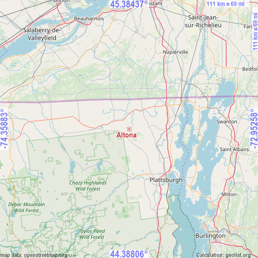
Altona GPS coordinates[2]
44° 53' 18.132" North, 73° 39' 20.52" West
| Map corner | latitude | longitude |
|---|---|---|
| Upper-left | 45.38437°, | -74.35883° |
| Center: | 44.88837°, | -73.6557° |
| Lower-right: | 44.38806°, | -72.95258° |
| Map W x H: | 110.8×110.8 km | = 68.8×68.8mi |
| max Lat: | 71.29058° ⇑8% North |
| Altona: | 44.88837° |
| min Lat: | ⇓92% South 19.06759° |
| min Long | Altona | max Long |
| -171.73463° | -73.6557° | -66.98998° |
| W 92.3%⇐ | ⇒7.7% E |
Elevation
Elevation of Altona is 196 m = 643 ft, and this is 98.8 m = 324 ft below average elevation for this country.
| Max E: |
3189 m = 10463 ft | 50.5% |
| Avg. | 294.8 m = 967 ft | |
| Altona | 196 m = 643 ft | |
Min E: |
-60 m = -197 ft | 49.5% |
See also: United States elevation on elevation.city.
Geographical zone
Altona is located in North temperate zone (between Tropic of Cancer and the Arctic Circle). Distance of this Northern Tropic circle is 2385.2 km =1482.1 mi to South.| Distance of | km | miles | from Altona |
|---|---|---|---|
| North Pole | 5015.9 | 3116.7 | to North |
| Arctic Circle | 2410.1 | 1497.6 | to North |
| Tropic Cancer | 2385.2 | 1482.1 | to South |
| Equator | 4991.1 | 3101.3 | to South |


Nearby cities:
15 places around Altona: (largest is in red/bold)
• Champlain
19.7 km =12.2 mi,  56°
56°
• Chateaugay
33.6 km =20.9 mi,  277°
277°
• Chazy
17.3 km =10.7 mi,  89°
89°
• Cumberland Head
27.6 km =17.1 mi,  133°
133°
• Dannemora
19.3 km =12 mi,  196°
196°
• Keeseville
44.8 km =27.8 mi,  161°
161°
• Morrisonville
22.9 km =14.2 mi, 161°
• North Hero
30.8 km =19.1 mi,  101°
101°
• Peru
35.9 km =22.3 mi, 163°
• Plattsburgh
26.4 km =16.4 mi,  142°
142°
• Plattsburgh West
25.8 km =16 mi,  152°
152°
• Rouses Point
25.7 km =16 mi, 62°
• Saint Albans
45.9 km =28.5 mi, 100°
• Swanton
42 km =26.1 mi, 85°
• West Chazy
13.9 km =8.6 mi,  122°
122°
Sources, notices
• [Note1] Compared only with cities in United States existing in our database
• [Src1] Map data: © OpenStreetMap contributors (CC-BY-SA)
• [Src2] Other city data from geonames.org with taken over terms of usage.
• [Src3] Geographical zone / Annual Mean Temperature by Robert A. Rohde @ Wikipedia
