Plattsburgh geodata
Plattsburgh (New York) is a seat of a second-order administrative division; located in United States in America/New_York (GMT-4) time zone. With population of 19,806 people, there are 2544 cities with bigger population in this country. Compared to other cities in United States, 91.2% of cities are located further ↓South; 92.9% of cities are located further ←West and 80.3% of cities have higher elevation than Plattsburgh. Note1


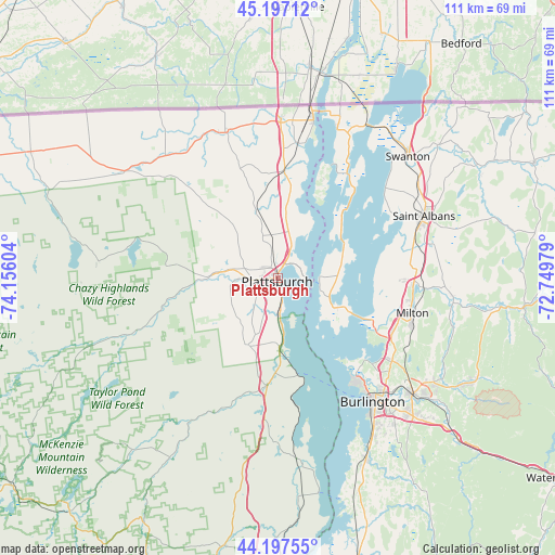
Plattsburgh GPS coordinates[2]
44° 41' 58.164" North, 73° 27' 10.476" West
| Map corner | latitude | longitude |
|---|---|---|
| Upper-left | 45.19712°, | -74.15604° |
| Center: | 44.69949°, | -73.45291° |
| Lower-right: | 44.19755°, | -72.74979° |
| Map W x H: | 111.1×111.1 km | = 69×69mi |
| max Lat: | 71.29058° ⇑8.8% North |
| Plattsburgh: | 44.69949° |
| min Lat: | ⇓91.2% South 19.06759° |
| min Long | Plattsburgh | max Long |
| -171.73463° | -73.45291° | -66.98998° |
| W 92.9%⇐ | ⇒7.1% E |
Elevation
Elevation of Plattsburgh is 45 m = 148 ft, and this is 249.8 m = 820 ft below average elevation for this country.
| Max E: |
3189 m = 10463 ft | 80.3% |
| Avg. | 294.8 m = 967 ft | |
| Plattsburgh | 45 m = 148 ft | |
Min E: |
-60 m = -197 ft | 19.7% |
See also: United States elevation on elevation.city.
Geographical zone
Plattsburgh is located in North temperate zone (between Tropic of Cancer and the Arctic Circle). Distance of this Northern Tropic circle is 2364.2 km =1469 mi to South.| Distance of | km | miles | from Plattsburgh |
|---|---|---|---|
| North Pole | 5036.9 | 3129.8 | to North |
| Arctic Circle | 2431.1 | 1510.6 | to North |
| Tropic Cancer | 2364.2 | 1469 | to South |
| Equator | 4970.1 | 3088.3 | to South |


Nearby cities:
15 places around Plattsburgh: (largest is in red/bold)
• Altona
26.4 km =16.4 mi,  322°
322°
• Burlington
31.3 km =19.4 mi,  142°
142°
• Chazy
21.2 km =13.2 mi,  3°
3°
• Colchester
29.7 km =18.5 mi,  125°
125°
• Cumberland Head
4.4 km =2.7 mi,  64°
64°
• Dannemora
21.5 km =13.4 mi,  276°
276°
• Keeseville
21.7 km =13.5 mi,  185°
185°
• Milton
27.9 km =17.3 mi,  103°
103°
• Morrisonville
8.7 km =5.4 mi,  265°
265°
• North Hero
20.4 km =12.7 mi,  44°
44°
• Peru
14.7 km =9.1 mi,  203°
203°
• Plattsburgh West
4.4 km =2.7 mi,  245°
245°
• Saint Albans
31.7 km =19.7 mi,  67°
67°
• West Chazy
14.1 km =8.8 mi,  342°
342°
• Winooski
31.3 km =19.4 mi, 137°
Sources, notices
• [Note1] Compared only with cities in United States existing in our database
• [Src1] Map data: © OpenStreetMap contributors (CC-BY-SA)
• [Src2] Other city data from geonames.org with taken over terms of usage.
• [Src3] Geographical zone / Annual Mean Temperature by Robert A. Rohde @ Wikipedia
