Keeseville geodata
Keeseville (New York) is a populated place; located in United States in America/New_York (GMT-4) time zone. With population of 1,750 people, there are 12737 cities with bigger population in this country. Compared to other cities in United States, 90.5% of cities are located further ↓South; 92.9% of cities are located further ←West and 65.2% of cities have higher elevation than Keeseville. Note1


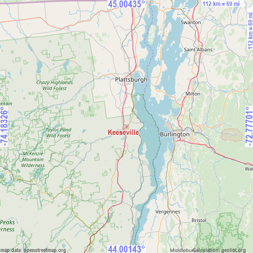
Keeseville GPS coordinates[2]
44° 30' 18.18" North, 73° 28' 48.468" West
| Map corner | latitude | longitude |
|---|---|---|
| Upper-left | 45.00435°, | -74.18326° |
| Center: | 44.50505°, | -73.48013° |
| Lower-right: | 44.00143°, | -72.77701° |
| Map W x H: | 111.5×111.5 km | = 69.3×69.3mi |
| max Lat: | 71.29058° ⇑9.5% North |
| Keeseville: | 44.50505° |
| min Lat: | ⇓90.5% South 19.06759° |
| min Long | Keeseville | max Long |
| -171.73463° | -73.48013° | -66.98998° |
| W 92.9%⇐ | ⇒7.1% E |
Elevation
Elevation of Keeseville is 127 m = 417 ft, and this is 167.8 m = 551 ft below average elevation for this country.
| Max E: |
3189 m = 10463 ft | 65.2% |
| Avg. | 294.8 m = 967 ft | |
| Keeseville | 127 m = 417 ft | |
Min E: |
-60 m = -197 ft | 34.8% |
See also: United States elevation on elevation.city.
Geographical zone
Keeseville is located in North temperate zone (between Tropic of Cancer and the Arctic Circle). Distance of this Northern Tropic circle is 2342.6 km =1455.6 mi to South.| Distance of | km | miles | from Keeseville |
|---|---|---|---|
| North Pole | 5058.6 | 3143.3 | to North |
| Arctic Circle | 2452.7 | 1524 | to North |
| Tropic Cancer | 2342.6 | 1455.6 | to South |
| Equator | 4948.5 | 3074.9 | to South |


Nearby cities:
15 places around Keeseville: (largest is in red/bold)
• Au Sable Forks
17 km =10.6 mi,  245°
245°
• Burlington
21.5 km =13.4 mi,  98°
98°
• Charlotte
27.8 km =17.3 mi,  141°
141°
• Colchester
26.7 km =16.6 mi,  80°
80°
• Cumberland Head
24.3 km =15.1 mi,  14°
14°
• Essex Junction
29.3 km =18.2 mi,  93°
93°
• Morrisonville
21.9 km =13.6 mi,  342°
342°
• Peru
9 km =5.6 mi, 335°
• Plattsburgh
21.7 km =13.5 mi, 5°
• Plattsburgh West
19.9 km =12.4 mi,  354°
354°
• Shelburne
24.4 km =15.2 mi,  124°
124°
• South Burlington
24.9 km =15.5 mi, 99°
• Willsboro
17.9 km =11.1 mi,  156°
156°
• Wilmington
29.6 km =18.4 mi,  244°
244°
• Winooski
23.4 km =14.5 mi, 93°
Sources, notices
• [Note1] Compared only with cities in United States existing in our database
• [Src1] Map data: © OpenStreetMap contributors (CC-BY-SA)
• [Src2] Other city data from geonames.org with taken over terms of usage.
• [Src3] Geographical zone / Annual Mean Temperature by Robert A. Rohde @ Wikipedia
