Cooperstown geodata
Cooperstown (New York) is a seat of a second-order administrative division; located in United States in America/New_York (GMT-4) time zone. With population of 1,792 people, there are 12567 cities with bigger population in this country. Compared to other cities in United States, 81.3% of cities are located further ↓South; 87.6% of cities are located further ←West and 82.1% of cities have lower elevation than Cooperstown. Note1


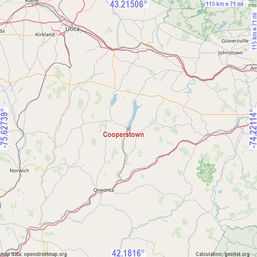
Cooperstown GPS coordinates[2]
42° 42' 1.728" North, 74° 55' 27.336" West
| Map corner | latitude | longitude |
|---|---|---|
| Upper-left | 43.21506°, | -75.62739° |
| Center: | 42.70048°, | -74.92426° |
| Lower-right: | 42.1816°, | -74.22114° |
| Map W x H: | 114.9×114.9 km | = 71.4×71.4mi |
| max Lat: | 71.29058° ⇑18.7% North |
| Cooperstown: | 42.70048° |
| min Lat: | ⇓81.3% South 19.06759° |
| min Long | Cooperstown | max Long |
| -171.73463° | -74.92426° | -66.98998° |
| W 87.6%⇐ | ⇒12.4% E |
Elevation
Elevation of Cooperstown is 377 m = 1237 ft, and this is 82.2 m = 270 ft above average elevation for this country.
| Max E: |
3189 m = 10463 ft | 17.9% |
| Cooperstown | 377 m 1237 ft | |
| Avg. | 294.8 m = 967 ft | |
Min E: |
-60 m = -197 ft | 82.1% |
See also: United States elevation on elevation.city.
Geographical zone
Cooperstown is located in North temperate zone (between Tropic of Cancer and the Arctic Circle). Distance of this Northern Tropic circle is 2141.9 km =1330.9 mi to South.| Distance of | km | miles | from Cooperstown |
|---|---|---|---|
| North Pole | 5259.2 | 3267.9 | to North |
| Arctic Circle | 2653.3 | 1648.7 | to North |
| Tropic Cancer | 2141.9 | 1330.9 | to South |
| Equator | 4747.8 | 2950.1 | to South |


Nearby cities:
15 places around Cooperstown: (largest is in red/bold)
• Cherry Valley
17.5 km =10.9 mi,  52°
52°
• Edmeston
26.1 km =16.2 mi,  269°
269°
• Hartwick
11.1 km =6.9 mi,  246°
246°
• Mohawk
35.2 km =21.9 mi,  349°
349°
• Morris
31.2 km =19.4 mi,  237°
237°
• New Berlin
34.4 km =21.4 mi,  255°
255°
• Oneonta
29.8 km =18.5 mi,  202°
202°
• Richfield Springs
17.7 km =11 mi,  343°
343°
• Richmondville
30.4 km =18.9 mi,  104°
104°
• Schenevus
18.8 km =11.7 mi,  153°
153°
• Sharon Springs
27.2 km =16.9 mi,  67°
67°
• Springfield
16.2 km =10.1 mi,  20°
20°
• West End
29.3 km =18.2 mi,  208°
208°
• West Winfield
30.1 km =18.7 mi,  313°
313°
• Worcester
18.7 km =11.6 mi,  130°
130°
Sources, notices
• [Note1] Compared only with cities in United States existing in our database
• [Src1] Map data: © OpenStreetMap contributors (CC-BY-SA)
• [Src2] Other city data from geonames.org with taken over terms of usage.
• [Src3] Geographical zone / Annual Mean Temperature by Robert A. Rohde @ Wikipedia
